ચિત્ર:Allied lines of communication in Southeast Asia, 1942-43.jpg
આ પૂર્વાવલોકનનું કદ: ૭૭૯ × ૬૦૦ પિક્સેલ. અન્ય આવર્તનો: ૩૧૨ × ૨૪૦ પિક્સેલ | ૬૨૪ × ૪૮૦ પિક્સેલ | ૯૯૮ × ૭૬૮ પિક્સેલ | ૧,૨૬૦ × ૯૭૦ પિક્સેલ.
મૂળભુત ફાઇલ (૧,૨૬૦ × ૯૭૦ પીક્સલ, ફાઇલનું કદ: ૪૫૦ KB, MIME પ્રકાર: image/jpeg)

|
This historical map image could be re-created using vector graphics as an SVG file. This has several advantages; see Commons:Media for cleanup for more information. If an SVG form of this image is available, please upload it and afterwards replace this template with
{{vector version available|new image name}}.
It is recommended to name the SVG file “Allied lines of communication in Southeast Asia, 1942-43.svg”—then the template Vector version available (or Vva) does not need the new image name parameter. |


સારાંશ:
| વર્ણન |
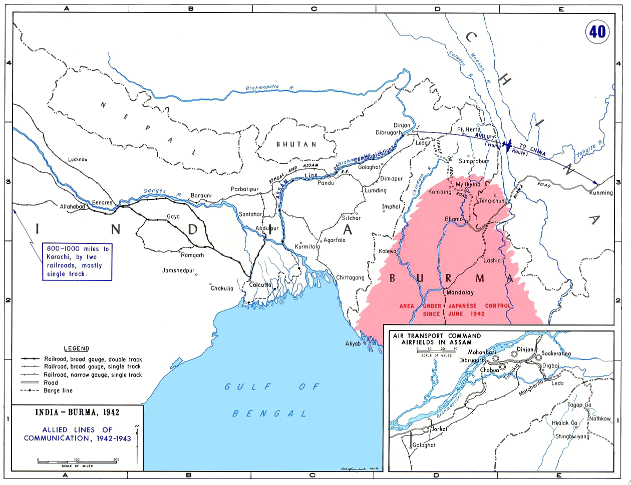
English: Allied lines of communication in India, Burma, and China in 1942–43. |
| તારીખ | અજ્ઞાત તારીખ |
| સ્રોત | [1] |
| લેખક | The Department of History, United States Military Academy |
| પરવાનગી (આ ફાઈલનો ફરી ઉપયોગ) |
In the public domain as an original work of the United States federal government and/or military [2] |
પરવાના
This work is in the public domain in the United States because it is a work prepared by an officer or employee of the United States Government as part of that person’s official duties under the terms of Title 17, Chapter 1, Section 105 of the US Code.
Note: This only applies to original works of the Federal Government and not to the work of any individual U.S. state, territory, commonwealth, county, municipality, or any other subdivision. This template also does not apply to postage stamp designs published by the United States Postal Service since 1978. (See § 313.6(C)(1) of Compendium of U.S. Copyright Office Practices). It also does not apply to certain US coins; see The US Mint Terms of Use.
|
 | |
| પ્રકાશન કાયદા હેઠળ અને તેને મળતા આવતાં આ ફાઈલ ને મુક્ત ગણાઈ છે | ||
ફાઇલનો ઇતિહાસ
તારીખ/સમય ઉપર ક્લિક કરવાથી તે સમયે ફાઇલ કેવી હતી તે જોવા મળશે.
| તારીખ/સમય | લઘુચિત્ર | પરિમાણો | સભ્ય | ટિપ્પણી | |
|---|---|---|---|---|---|
| વર્તમાન | ૨૨:૩૨, ૨૯ ડિસેમ્બર ૨૦૧૩ | | ૧,૨૬૦ × ૯૭૦ (૪૫૦ KB) | Hohum | Cleanup |
| ૦૭:૪૬, ૩૦ ઓગસ્ટ ૨૦૦૬ |  | ૧,૨૬૦ × ૯૭૦ (૧૭૬ KB) | Kirill Lokshin | {{Information |Description= Allied lines of communication in India, Burma, and China in 1942–43. |Source= [http://www.dean.usma.edu/history/web03/atlases/ww2%20pacific/ww2%20pacific%20%20pages/ww2%20pacific%20map%2040.htm] |Date= ? |Author= [http://www |
ફાઇલનો વપરાશ
આ ફાઇલ માં નીચેનું પાનું વપરાયેલું છે:
ફાઇલનો વ્યાપક ઉપયોગ
નીચેની બીજી વિકિઓ આ ફાઈલ વાપરે છે:
- ast.wikipedia.org પર વપરાશ
- as.wikipedia.org પર વપરાશ
- da.wikipedia.org પર વપરાશ
- de.wikipedia.org પર વપરાશ
- en.wikipedia.org પર વપરાશ
- es.wikipedia.org પર વપરાશ
- fa.wikipedia.org પર વપરાશ
- fr.wikipedia.org પર વપરાશ
- he.wikipedia.org પર વપરાશ
- hi.wikipedia.org પર વપરાશ
- hr.wikipedia.org પર વપરાશ
- id.wikipedia.org પર વપરાશ
- it.wikipedia.org પર વપરાશ
- ja.wikipedia.org પર વપરાશ
- lv.wikipedia.org પર વપરાશ
- my.wikipedia.org પર વપરાશ
- nl.wikipedia.org પર વપરાશ
- no.wikipedia.org પર વપરાશ
- pt.wikipedia.org પર વપરાશ
- ru.wikipedia.org પર વપરાશ
- sh.wikipedia.org પર વપરાશ
- www.wikidata.org પર વપરાશ
- zh.wikipedia.org પર વપરાશ