ચિત્ર:NImap-CIA.jpg

આ પૂર્વાવલોકનનું કદ: ૭૨૭ × ૫૯૯ પિક્સેલ. અન્ય આવર્તનો: ૨૯૧ × ૨૪૦ પિક્સેલ | ૫૮૨ × ૪૮૦ પિક્સેલ | ૯૩૨ × ૭૬૮ પિક્સેલ | ૧,૨૫૨ × ૧,૦૩૨ પિક્સેલ.
મૂળભુત ફાઇલ (૧,૨૫૨ × ૧,૦૩૨ પીક્સલ, ફાઇલનું કદ: ૨૭૪ KB, MIME પ્રકાર: image/jpeg)
સારાંશ:
| વર્ણન |
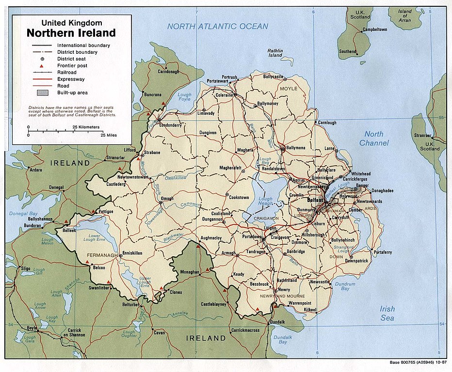
English: Map of Northern Ireland. |
| તારીખ | |
| સ્રોત | Northern Ireland (U.K) (Political) 1987 from Perry-Castañeda Library Map Collection: Europe Maps |
| લેખક | U.S. Central Intelligence Agency |
| પરવાનગી (આ ફાઈલનો ફરી ઉપયોગ) |
Public domain |
પરવાના
| This image is a work of a Central Intelligence Agency employee, taken or made as part of that person's official duties. As a Work of the United States Government, this image or media is in the public domain in the United States.
|

|
ફાઇલનો ઇતિહાસ
તારીખ/સમય ઉપર ક્લિક કરવાથી તે સમયે ફાઇલ કેવી હતી તે જોવા મળશે.
| તારીખ/સમય | લઘુચિત્ર | પરિમાણો | સભ્ય | ટિપ્પણી | |
|---|---|---|---|---|---|
| વર્તમાન | ૧૪:૩૬, ૧૧ જાન્યુઆરી ૨૦૦૫ | | ૧,૨૫૨ × ૧,૦૩૨ (૨૭૪ KB) | Hoshie | CIA map of Northern Ireland, from [http://www.lib.utexas.edu/maps/europe/northern_ireland_pol87.jpg]. |
ફાઇલનો વપરાશ
આ ફાઇલ માં નીચેનું પાનું વપરાયેલું છે:
ફાઇલનો વ્યાપક ઉપયોગ
નીચેની બીજી વિકિઓ આ ફાઈલ વાપરે છે:
- als.wikipedia.org પર વપરાશ
- bn.wikipedia.org પર વપરાશ
- ca.wikipedia.org પર વપરાશ
- cs.wikipedia.org પર વપરાશ
- cv.wikipedia.org પર વપરાશ
- de.wikipedia.org પર વપરાશ
- dsb.wikipedia.org પર વપરાશ
- el.wikipedia.org પર વપરાશ
- en.wikipedia.org પર વપરાશ
- es.wikipedia.org પર વપરાશ
- fa.wikipedia.org પર વપરાશ
- fi.wikipedia.org પર વપરાશ
- frr.wikipedia.org પર વપરાશ
- fr.wikipedia.org પર વપરાશ
- he.wikipedia.org પર વપરાશ
- id.wikipedia.org પર વપરાશ
- is.wikipedia.org પર વપરાશ
- it.wikipedia.org પર વપરાશ
- it.wikinews.org પર વપરાશ
- ja.wikipedia.org પર વપરાશ
- kn.wikipedia.org પર વપરાશ
- lfn.wikipedia.org પર વપરાશ
- mr.wikipedia.org પર વપરાશ
- nl.wikipedia.org પર વપરાશ
- os.wikipedia.org પર વપરાશ
- pt.wikipedia.org પર વપરાશ
- qu.wikipedia.org પર વપરાશ
- rmy.wikipedia.org પર વપરાશ
- sco.wikipedia.org પર વપરાશ
- sh.wikipedia.org પર વપરાશ
- simple.wikipedia.org પર વપરાશ
- si.wikipedia.org પર વપરાશ
આ ફાઇલના વધુ વૈશ્વિક વપરાશ જુઓ.