ચિત્ર:Aral Sea Continues to Shrink, August 2009.jpg

આ પૂર્વાવલોકનનું કદ: ૬૦૦ × ૬૦૦ પિક્સેલ. અન્ય આવર્તનો: ૨૪૦ × ૨૪૦ પિક્સેલ | ૪૮૦ × ૪૮૦ પિક્સેલ | ૭૬૮ × ૭૬૮ પિક્સેલ | ૧,૦૨૪ × ૧,૦૨૪ પિક્સેલ | ૨,૦૦૦ × ૨,૦૦૦ પિક્સેલ.
મૂળભુત ફાઇલ (૨,૦૦૦ × ૨,૦૦૦ પીક્સલ, ફાઇલનું કદ: ૮૮૯ KB, MIME પ્રકાર: image/jpeg)
સારાંશ:
| વર્ણન |
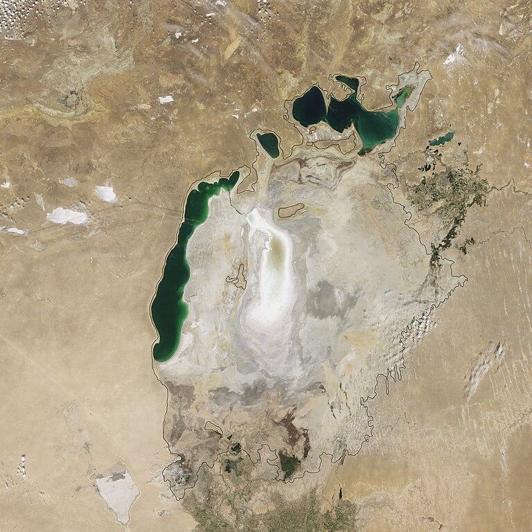
English: This true-colour image shows that by August 2009, virtually nothing remained of the Southern Aral Sea’s eastern lobe. Although the Northern Aral Sea (upper right) still appears healthy, the Southern Aral Sea consists of two isolated water bodies: an irregular oval shape directly south-west of the Northern Aral Sea, and the long, thin remainder of the Southern Aral Sea’s far western lobe. Although the faintest glimmers of blue-green appear in the eastern lobe, earth tones predominate, surrounded by a ghostly film of pale beige. Lake sediments from this depleted water body have provided ample material for frequent dust storms. The black line shows the lake shore ca. 1960. |
| તારીખ | |
| સ્રોત | NASA Earth Observatory |
| લેખક | Jesse Allen |
Image created using data obtained from the Goddard Level 1 and Atmospheric Archive and Distribution System (LAADS). Instrument: Terra - MODIS.
પરવાના
| This file is in the public domain in the United States because it was solely created by NASA. NASA copyright policy states that "NASA material is not protected by copyright unless noted". (See Template:PD-USGov, NASA copyright policy page or JPL Image Use Policy.) | ||
 |
Warnings:
|
ફાઇલનો ઇતિહાસ
તારીખ/સમય ઉપર ક્લિક કરવાથી તે સમયે ફાઇલ કેવી હતી તે જોવા મળશે.
| તારીખ/સમય | લઘુચિત્ર | પરિમાણો | સભ્ય | ટિપ્પણી | |
|---|---|---|---|---|---|
| વર્તમાન | ૧૪:૨૯, ૨૭ ઓગસ્ટ ૨૦૦૯ | | ૨,૦૦૦ × ૨,૦૦૦ (૮૮૯ KB) | Originalwana | {{Information |Description={{en|1=This true-colour image shows that by August 2009, virtually nothing remained of the Southern Aral Sea’s eastern lobe. Although the Northern Aral Sea (upper right) still appears healthy, the Southern Aral Sea consists of |
ફાઇલનો વપરાશ
આ ફાઇલ માં નીચેનું પાનું વપરાયેલું છે:
ફાઇલનો વ્યાપક ઉપયોગ
નીચેની બીજી વિકિઓ આ ફાઈલ વાપરે છે:
- af.wikipedia.org પર વપરાશ
- az.wikipedia.org પર વપરાશ
- bg.wikipedia.org પર વપરાશ
- bxr.wikipedia.org પર વપરાશ
- ca.wikipedia.org પર વપરાશ
- ce.wikipedia.org પર વપરાશ
- ckb.wikipedia.org પર વપરાશ
- en.wikipedia.org પર વપરાશ
- es.wikipedia.org પર વપરાશ
- eu.wikipedia.org પર વપરાશ
- fr.wikipedia.org પર વપરાશ
- hy.wikipedia.org પર વપરાશ
- kk.wikipedia.org પર વપરાશ
- ko.wikipedia.org પર વપરાશ
- lt.wikipedia.org પર વપરાશ
- mn.wikipedia.org પર વપરાશ
- myv.wikipedia.org પર વપરાશ
- nn.wikipedia.org પર વપરાશ
- pl.wikipedia.org પર વપરાશ
- ru.wikipedia.org પર વપરાશ
- simple.wikipedia.org પર વપરાશ
- sk.wikipedia.org પર વપરાશ
- sv.wikipedia.org પર વપરાશ
- tr.wikipedia.org પર વપરાશ
- uk.wikipedia.org પર વપરાશ
- uz.wikipedia.org પર વપરાશ
- zh.wikipedia.org પર વપરાશ