ચિત્ર:Aral sea 1985 from STS.jpg
આથી વધુ ઘનત્વ ઉપલબ્ધ નથી.
Aral_sea_1985_from_STS.jpg (૬૦૬ × ૫૯૯ પીક્સલ, ફાઇલનું કદ: ૧૩૨ KB, MIME પ્રકાર: image/jpeg)
| વર્ણન |
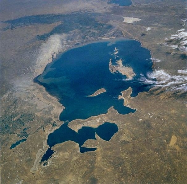
English: The Aral Sea, the fourth largest lake in the world, can be seen in this low-oblique, south-looking view. When this photograph was taken by the STS-51-F mission, the Aral Sea covered an area of approximately 26 000 square miles (67 000 square kilometers), was approximately 260 miles (420 kilometers) long, 175 miles (280 kilometers) wide, and had an average depth of 33 feet (10 meters) and a maximum depth of 220 feet (70 meters). |
| તારીખ | |
| સ્રોત | http://eol.jsc.nasa.gov/sseop/EFS/photoinfo.pl?PHOTO=STS51F-36-59 |
| લેખક | NASA |
| This file is in the public domain in the United States because it was solely created by NASA. NASA copyright policy states that "NASA material is not protected by copyright unless noted". (See Template:PD-USGov, NASA copyright policy page or JPL Image Use Policy.) | ||
 |
Warnings:
|
ફાઇલનો ઇતિહાસ
તારીખ/સમય ઉપર ક્લિક કરવાથી તે સમયે ફાઇલ કેવી હતી તે જોવા મળશે.
| તારીખ/સમય | લઘુચિત્ર | પરિમાણો | સભ્ય | ટિપ્પણી | |
|---|---|---|---|---|---|
| વર્તમાન | ૧૨:૦૮, ૨૪ જુલાઇ ૨૦૧૦ | | ૬૦૬ × ૫૯૯ (૧૩૨ KB) | Kreuzschnabel | EXIF data removed |
| ૨૨:૧૧, ૨૩ જુલાઇ ૨૦૧૦ |  | ૬૦૬ × ૫૯૯ (૩૪૯ KB) | Kreuzschnabel | image turned by 180 degrees - it was upside-down, the view onto the northern coast being definitely steeper than the other side | |
| ૦૭:૩૭, ૯ નવેમ્બર ૨૦૦૫ |  | ૬૦૬ × ૫૯૯ (૩૪૯ KB) | PiccoloNamek~commonswiki | ||
| ૧૪:૨૭, ૧૫ જુલાઇ ૨૦૦૫ |  | ૬૦૬ × ૫૯૯ (૨૨૪ KB) | Li-sung | Aral Sea - August 1985 image description [http://eol.jsc.nasa.gov/sseop/EFS/photoinfo.pl?PHOTO=STS51F-36-59 here] {{PD-USGov-NASA}} |
ફાઇલનો વપરાશ
આ ફાઇલ માં નીચેનું પાનું વપરાયેલું છે:
ફાઇલનો વ્યાપક ઉપયોગ
નીચેની બીજી વિકિઓ આ ફાઈલ વાપરે છે:
- af.wikipedia.org પર વપરાશ
- ast.wikipedia.org પર વપરાશ
- azb.wikipedia.org પર વપરાશ
- bg.wikipedia.org પર વપરાશ
- ca.wikipedia.org પર વપરાશ
- ckb.wikipedia.org પર વપરાશ
- de.wikipedia.org પર વપરાશ
- el.wiktionary.org પર વપરાશ
- en.wikipedia.org પર વપરાશ
- eo.wikipedia.org પર વપરાશ
- es.wikipedia.org પર વપરાશ
- fi.wikipedia.org પર વપરાશ
- frr.wikipedia.org પર વપરાશ
- fr.wikipedia.org પર વપરાશ
- fy.wikipedia.org પર વપરાશ
- he.wikipedia.org પર વપરાશ
- hif.wikipedia.org પર વપરાશ
- hr.wikipedia.org પર વપરાશ
- it.wikipedia.org પર વપરાશ
- kk.wikipedia.org પર વપરાશ
- km.wikipedia.org પર વપરાશ
- ko.wikipedia.org પર વપરાશ
- lmo.wikipedia.org પર વપરાશ
- lt.wikipedia.org પર વપરાશ
- ms.wikipedia.org પર વપરાશ
- nn.wikipedia.org પર વપરાશ
- pt.wikipedia.org પર વપરાશ
- ro.wikipedia.org પર વપરાશ
- sh.wikipedia.org પર વપરાશ
- simple.wikipedia.org પર વપરાશ
- sk.wikipedia.org પર વપરાશ
- sr.wikipedia.org પર વપરાશ
- sv.wikipedia.org પર વપરાશ
- sw.wikipedia.org પર વપરાશ
- ta.wikipedia.org પર વપરાશ
- th.wikipedia.org પર વપરાશ
- tr.wikipedia.org પર વપરાશ
આ ફાઇલના વધુ વૈશ્વિક વપરાશ જુઓ.