ચિત્ર:Cape Town 2011 population density map.svg

Size of this PNG preview of this SVG file: ૪૦૫ × ૫૯૯ પિક્સેલ. અન્ય આવર્તનો: ૧૬૨ × ૨૪૦ પિક્સેલ | ૩૨૪ × ૪૮૦ પિક્સેલ | ૫૧૯ × ૭૬૮ પિક્સેલ | ૬૯૨ × ૧,૦૨૪ પિક્સેલ | ૧,૩૮૫ × ૨,૦૪૮ પિક્સેલ | ૭૭૧ × ૧,૧૪૦ પિક્સેલ.
મૂળભુત ફાઇલ (SVG ફાઇલ, માત્ર ૭૭૧ × ૧,૧૪૦ પીક્સલ, ફાઇલનું કદ: ૭૬૧ KB)
સારાંશ:
| વર્ણન |
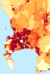
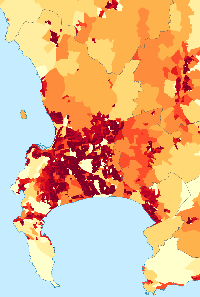
English: Population density map of the City of Cape Town, Western Cape, South Africa, from the 2011 Census, at the "Small Area" level.
<1 inhabitant/km²
1–3 inhabitants/km²
3–10 inhabitants/km²
10–30 inhabitants/km²
30–100 inhabitants/km²
100–300 inhabitants/km²
300–1000 inhabitants/km²
1000–3000 inhabitants/km²
>3000 inhabitants/km² |
| તારીખ | |
| સ્રોત | Statistics South Africa's Census 2011 is the source of the basic population data. The map results from my own processing of the data. |
| લેખક | Htonl |
| પરવાનગી (આ ફાઈલનો ફરી ઉપયોગ) |
http://beta2.statssa.gov.za/?page_id=425 |
પરવાના
The following license applies to the population data on which the map is based:
 |
The copyright holder of this file allows anyone to use it
for any purpose, provided that the user acknowledges Stats SA as the source of the basic data wherever they process, apply, utilise, publish or distribute the data, and also that they specify that the relevant application and analysis (where applicable) result from their own processing of the data..
Usage notes:
|
|
Please check that the conditions given above are compliant to the Commons licensing policy. Most importantly, derivative work and commercial use must be allowed.
|
The following tag applies to the map itself:
| હું, આ રચનાઓ પ્રકાશન અધિકાર ધારક, આ રચનાને public domain પર પ્રકાશિત કરું છું. આ સમગ્ર વિશ્વમઆં કાર્યરત રહેશે. અમુક દેશોમાં કાયદેસર રીતે તે શક્ય નથી, જો તેમ હોય તો : કો કોઈને પણ કોઈપણ વપરાશ, કોઇ પણ શરત વગર, માટે આ રચના વાપરવાની છૂટ આપું છું સિવાયકે તે શરતો કાયદેસર જરૂરી હોય. |
ફાઇલનો ઇતિહાસ
તારીખ/સમય ઉપર ક્લિક કરવાથી તે સમયે ફાઇલ કેવી હતી તે જોવા મળશે.
| તારીખ/સમય | લઘુચિત્ર | પરિમાણો | સભ્ય | ટિપ્પણી | |
|---|---|---|---|---|---|
| વર્તમાન | ૨૩:૩૫, ૨૬ સપ્ટેમ્બર ૨૦૧૫ | | ૭૭૧ × ૧,૧૪૦ (૭૬૧ KB) | Htonl | style/size tweak |
| ૧૯:૫૫, ૧૩ ઓક્ટોબર ૨૦૧૩ |  | ૭૧૮ × ૧,૦૪૫ (૫૦૫ KB) | Htonl | == {{int:filedesc}} == {{Information |Description={{en|1=Population density map of the City of Cape Town, Western Cape, South Africa, from the 2011 Census, at the "Small Area" level. {{legend|#ffffcc|<1 inhabitant/km²}} {{legend|#ffeda0|1–3 inhab... |
ફાઇલનો વપરાશ
આ ફાઇલ માં નીચેનું પાનું વપરાયેલું છે:
ફાઇલનો વ્યાપક ઉપયોગ
નીચેની બીજી વિકિઓ આ ફાઈલ વાપરે છે:
- be.wikipedia.org પર વપરાશ
- de.wikipedia.org પર વપરાશ
- en.wikipedia.org પર વપરાશ
- gl.wikipedia.org પર વપરાશ
- he.wikipedia.org પર વપરાશ
- hu.wikipedia.org પર વપરાશ
- hy.wikipedia.org પર વપરાશ
- ja.wikipedia.org પર વપરાશ
- ka.wikipedia.org પર વપરાશ
- ko.wikipedia.org પર વપરાશ
- mk.wikipedia.org પર વપરાશ
- nso.wikipedia.org પર વપરાશ
- pt.wikipedia.org પર વપરાશ
- ro.wikipedia.org પર વપરાશ
- sw.wikipedia.org પર વપરાશ
- uk.wikipedia.org પર વપરાશ
- xh.wikipedia.org પર વપરાશ