ચિત્ર:EU Pop2008 1024.PNG

આ પૂર્વાવલોકનનું કદ: ૬૦૦ × ૫૯૯ પિક્સેલ. અન્ય આવર્તનો: ૨૪૦ × ૨૪૦ પિક્સેલ | ૪૮૧ × ૪૮૦ પિક્સેલ | ૭૬૯ × ૭૬૮ પિક્સેલ | ૧,૦૨૫ × ૧,૦૨૪ પિક્સેલ | ૧,૫૩૬ × ૧,૫૩૪ પિક્સેલ.
મૂળભુત ફાઇલ (૧,૫૩૬ × ૧,૫૩૪ પીક્સલ, ફાઇલનું કદ: ૨૪૯ KB, MIME પ્રકાર: image/png)

|
This demographic map image could be re-created using vector graphics as an SVG file. This has several advantages; see Commons:Media for cleanup for more information. If an SVG form of this image is available, please upload it and afterwards replace this template with
{{vector version available|new image name}}.
It is recommended to name the SVG file “EU Pop2008 1024.svg”—then the template Vector version available (or Vva) does not need the new image name parameter. |
સારાંશ:
| વર્ણન |
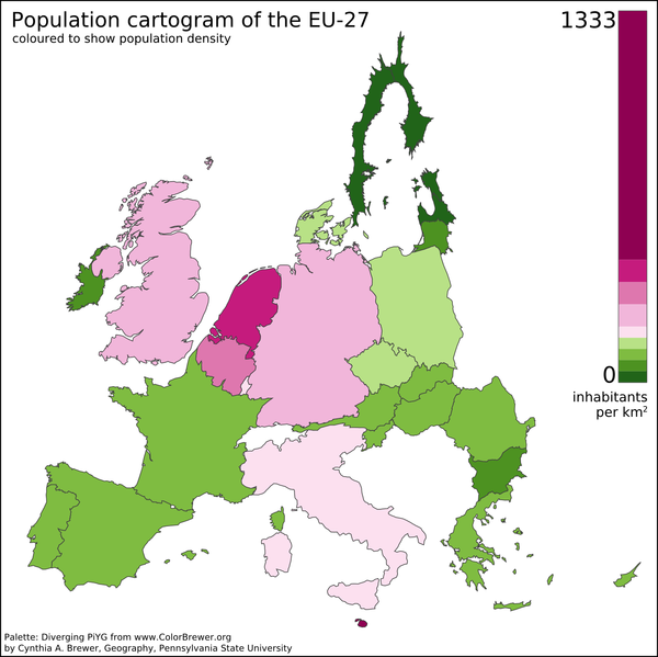
English: A preliminary population cartogram of the EU-27 made with ScapeToad 1.1 using a cut-down and reprojected public domain world shapefile (projection: Lambert Azimuthal Equal Area) and January 2008 population data from Eurostat. This version includes Dutch barrier islands. |
| તારીખ | |
| સ્રોત | પોતાની રચના |
| લેખક | Vinny Burgoo |
| અન્ય આવૃત્તિઓ | Derivative works of this file: EU Pop2008 1024 new.png |
See also Geoilex's EU cartogram.
પરવાના
| હું, આ રચનાઓ પ્રકાશન અધિકાર ધારક, આ રચનાને public domain પર પ્રકાશિત કરું છું. આ સમગ્ર વિશ્વમઆં કાર્યરત રહેશે. અમુક દેશોમાં કાયદેસર રીતે તે શક્ય નથી, જો તેમ હોય તો : કો કોઈને પણ કોઈપણ વપરાશ, કોઇ પણ શરત વગર, માટે આ રચના વાપરવાની છૂટ આપું છું સિવાયકે તે શરતો કાયદેસર જરૂરી હોય. |
ફાઇલનો ઇતિહાસ
તારીખ/સમય ઉપર ક્લિક કરવાથી તે સમયે ફાઇલ કેવી હતી તે જોવા મળશે.
| તારીખ/સમય | લઘુચિત્ર | પરિમાણો | સભ્ય | ટિપ્પણી | |
|---|---|---|---|---|---|
| વર્તમાન | ૨૨:૩૪, ૧૧ નવેમ્બર ૨૦૧૨ | | ૧,૫૩૬ × ૧,૫૩૪ (૨૪૯ KB) | Veikk0.ma | Optimised with OptiPNG. |
| ૦૦:૧૨, ૨૮ જુલાઇ ૨૦૦૮ |  | ૧,૫૩૬ × ૧,૫૩૪ (૩૬૬ KB) | Vinny Burgoo | {{Information |Description= |Source= |Date= |Author= |Permission= |other_versions= }} | |
| ૦૪:૪૨, ૧૫ જુલાઇ ૨૦૦૮ |  | ૧,૦૫૪ × ૧,૦૨૪ (૨૧૦ KB) | Vinny Burgoo | {{Information |Description= |Source= |Date= |Author= |Permission= |other_versions= }} | |
| ૦૭:૧૩, ૧૪ જૂન ૨૦૦૮ |  | ૧,૦૨૪ × ૧,૦૨૪ (૨૩૩ KB) | Vinny Burgoo | {{Information |Description= |Source= |Date= |Author= |Permission= |other_versions= }} | |
| ૦૧:૨૫, ૭ જૂન ૨૦૦૮ |  | ૧,૦૨૪ × ૭૬૮ (૬૧ KB) | Vinny Burgoo | {{Information |Description={{en|1=A preliminary population cartogram of the EU-27 made with [http://chorogram.choros.ch/scapetoad/ ScapeToad] and data and shapefiles from ... can't remember.}} |Source=Own work by uploader |Author=[[User:Vinny Burgoo|Vinny |
ફાઇલનો વપરાશ
આ ફાઇલ માં નીચેનું પાનું વપરાયેલું છે:
ફાઇલનો વ્યાપક ઉપયોગ
નીચેની બીજી વિકિઓ આ ફાઈલ વાપરે છે:
- af.wikipedia.org પર વપરાશ
- ar.wikipedia.org પર વપરાશ
- cs.wikipedia.org પર વપરાશ
- en.wikipedia.org પર વપરાશ
- fi.wikipedia.org પર વપરાશ
- hi.wikipedia.org પર વપરાશ
- it.wikipedia.org પર વપરાશ
- ja.wikipedia.org પર વપરાશ
- ms.wikipedia.org પર વપરાશ
- pt.wikipedia.org પર વપરાશ
- sv.wikipedia.org પર વપરાશ
- ta.wikipedia.org પર વપરાશ
- tw.wikipedia.org પર વપરાશ
- uk.wikipedia.org પર વપરાશ
- ur.wikipedia.org પર વપરાશ