ચિત્ર:IndonesiaBali.png
આથી વધુ ઘનત્વ ઉપલબ્ધ નથી.
IndonesiaBali.png (૮૦૦ × ૩૭૫ પીક્સલ, ફાઇલનું કદ: ૭૯ KB, MIME પ્રકાર: image/png)
સારાંશ:
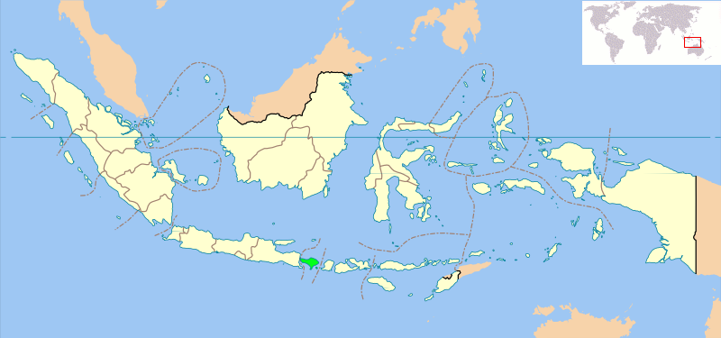
Locator map of Indonesian province of Bali showing provincial boundaries. Based on Image:Indonesia_provinces_blank_map.svg. Created for use in en:Wikiproject Indonesia Cartography.
NB: Please note, this map will probably need further editing in order to make the position of Bali clearer. For now, we are simply standardising all Indonesia Provincial locator maps, and will make additional changes once all standard maps have been uploaded
પરવાના
| આ ફાઈલ વપરાશની પરવાનગી : Creative Commons Attribution-Share Alike 3.0 Unported license. Subject to disclaimers. | ||
| ||
| GFDL licensing update ના ભાગ રૂપે આ પરવાનાનો ટેગ ફાઈલ પર લગાડવામાં આવ્યો છે. |

|
આ રચનાની નકલ કરવા, વિતરણ અને સુધારો કરવા માટે GNU Free Documentation License, આવૃત્તિ 1.2 કે અન્ય આગળની આવૃત્તિ Free Software Foundation હેઠળ પરવાનગી છે; જેમાં કોઈ Invariant Sections, no Front-Cover Texts, and no Back-Cover Texts નથી. આ પરવાનાની પ્રત GNU Free Documentation License વિભાગમાં છે. Subject to disclaimers. |
ફાઇલનો ઇતિહાસ
તારીખ/સમય ઉપર ક્લિક કરવાથી તે સમયે ફાઇલ કેવી હતી તે જોવા મળશે.
| તારીખ/સમય | લઘુચિત્ર | પરિમાણો | સભ્ય | ટિપ્પણી | |
|---|---|---|---|---|---|
| વર્તમાન | ૧૫:૫૮, ૧૪ સપ્ટેમ્બર ૨૦૦૮ | | ૮૦૦ × ૩૭૫ (૭૯ KB) | AnonyLog | Added world locator from last version. |
| ૧૮:૩૮, ૬ માર્ચ ૨૦૦૭ |  | ૮૦૦ × ૩૭૫ (૯૭ KB) | Bwmodular | New version of Locator Map, higher resolution map, standard across all Indonesian Province maps, showing West Irian Jaya province. | |
| ૦૫:૦૨, ૩ ઓક્ટોબર ૨૦૦૫ |  | ૩૦૦ × ૨૨૦ (૧૪ KB) | Romanm | uploaded current version from English Wikipedia | |
| ૦૬:૨૯, ૨ ઓક્ટોબર ૨૦૦૫ |  | ૩૦૦ × ૨૨૦ (૧૪ KB) | Fangz~commonswiki | Reduced file size. Jeez, I'm making alot of mistakes, eh? | |
| ૦૬:૨૫, ૨ ઓક્ટોબર ૨૦૦૫ |  | ૩૦૦ × ૨૨૦ (૨૮ KB) | Fangz~commonswiki | Reverted to earlier revision | |
| ૦૬:૨૪, ૨ ઓક્ટોબર ૨૦૦૫ | ૩૦૦ × ૧૨૨ (૭ KB) | Fangz~commonswiki | Reverted to earlier revision | ||
| ૦૬:૨૩, ૨ ઓક્ટોબર ૨૦૦૫ |  | ૩૦૦ × ૨૨૦ (૨૮ KB) | Fangz~commonswiki | Edited to give global context. (Using BlankMap-World.png) Done using the Gimp | |
| ૧૧:૦૬, ૧૪ ઓગસ્ટ ૨૦૦૫ | ૩૦૦ × ૧૨૨ (૭ KB) | *drew~commonswiki | Map of Indonesia showing the location of Bali. Taken from English Wikipedia. {{GFDL}} Category:Bali |
ફાઇલનો વપરાશ
આ ફાઇલ માં નીચેનું પાનું વપરાયેલું છે:
ફાઇલનો વ્યાપક ઉપયોગ
નીચેની બીજી વિકિઓ આ ફાઈલ વાપરે છે:
- ar.wikipedia.org પર વપરાશ
- arz.wikipedia.org પર વપરાશ
- ast.wikipedia.org પર વપરાશ
- bcl.wikipedia.org પર વપરાશ
- be-tarask.wikipedia.org પર વપરાશ
- bjn.wikipedia.org પર વપરાશ
- bn.wikipedia.org પર વપરાશ
- bs.wikipedia.org પર વપરાશ
- ca.wikipedia.org પર વપરાશ
- ceb.wikipedia.org પર વપરાશ
- de.wikipedia.org પર વપરાશ
- de.wikinews.org પર વપરાશ
- el.wikipedia.org પર વપરાશ
- en.wikipedia.org પર વપરાશ
- eo.wikipedia.org પર વપરાશ
- es.wikinews.org પર વપરાશ
- eu.wikipedia.org પર વપરાશ
- fa.wikipedia.org પર વપરાશ
- fi.wikipedia.org પર વપરાશ
- fo.wikipedia.org પર વપરાશ
- fr.wikipedia.org પર વપરાશ
- fy.wikipedia.org પર વપરાશ
- gl.wikipedia.org પર વપરાશ
- hak.wikipedia.org પર વપરાશ
- he.wikipedia.org પર વપરાશ
- hy.wikipedia.org પર વપરાશ
- ja.wikipedia.org પર વપરાશ
- ja.wikinews.org પર વપરાશ
- ka.wikipedia.org પર વપરાશ
- km.wiktionary.org પર વપરાશ
- kn.wikipedia.org પર વપરાશ
- la.wiktionary.org પર વપરાશ
- lt.wikipedia.org પર વપરાશ
- lv.wikipedia.org પર વપરાશ
- mai.wikipedia.org પર વપરાશ
- mk.wikipedia.org પર વપરાશ
- ml.wikipedia.org પર વપરાશ
- ms.wikipedia.org પર વપરાશ
- ne.wikipedia.org પર વપરાશ
- nl.wikipedia.org પર વપરાશ
આ ફાઇલના વધુ વૈશ્વિક વપરાશ જુઓ.