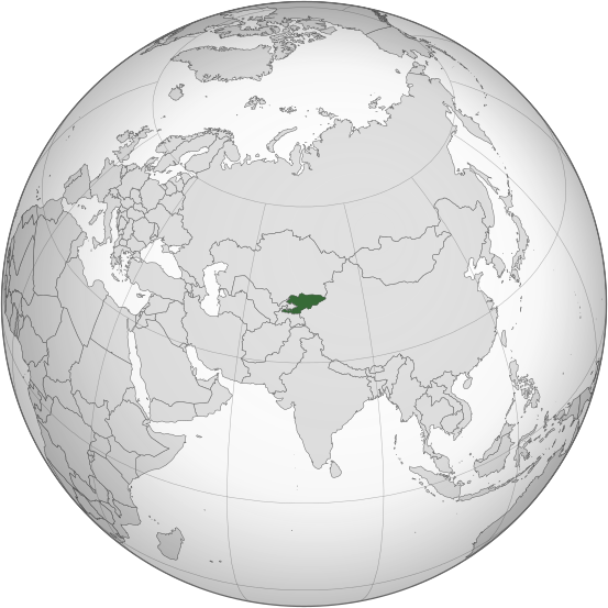
ચિત્ર:Kyrgyzstan (orthographic projection).svg

Size of this PNG preview of this SVG file: ૫૫૩ × ૫૫૩ પિક્સેલ. અન્ય આવર્તનો: ૨૪૦ × ૨૪૦ પિક્સેલ | ૪૮૦ × ૪૮૦ પિક્સેલ | ૭૬૮ × ૭૬૮ પિક્સેલ | ૧,૦૨૪ × ૧,૦૨૪ પિક્સેલ | ૨,૦૪૮ × ૨,૦૪૮ પિક્સેલ.
મૂળભુત ફાઇલ (SVG ફાઇલ, માત્ર ૫૫૩ × ૫૫૩ પીક્સલ, ફાઇલનું કદ: ૩૪૬ KB)
ફાઇલનો ઇતિહાસ
તારીખ/સમય ઉપર ક્લિક કરવાથી તે સમયે ફાઇલ કેવી હતી તે જોવા મળશે.
| તારીખ/સમય | લઘુચિત્ર | પરિમાણો | સભ્ય | ટિપ્પણી | |
|---|---|---|---|---|---|
| વર્તમાન | ૦૬:૩૮, ૩૧ જુલાઇ ૨૦૨૩ |  | ૫૫૩ × ૫૫૩ (૩૪૬ KB) | Cutlass | rv sock edits |
| ૨૧:૩૯, ૬ જૂન ૨૦૨૩ |  | ૫૫૩ × ૫૫૩ (૩૧૦ KB) | Cutlerys | Reverted to version as of 12:34, 4 August 2013 (UTC) | |
| ૨૧:૩૮, ૬ જૂન ૨૦૨૩ |  | ૫૫૩ × ૫૫૩ (૩૦૬ KB) | Cutlerys | Reverted to version as of 23:39, 16 March 2015 (UTC) | |
| ૨૩:૪૭, ૧ મે ૨૦૧૬ |  | ૫૫૩ × ૫૫૩ (૩૪૬ KB) | Nicolay Sidorov | ... | |
| ૦૫:૦૯, ૧૭ માર્ચ ૨૦૧૫ |  | ૫૫૩ × ૫૫૩ (૩૦૬ KB) | Flappiefh | Removed Somaliland and Kosovo. Separated Western Sahara and Morroco. | |
| ૧૮:૦૪, ૪ ઓગસ્ટ ૨૦૧૩ |  | ૫૫૩ × ૫૫૩ (૩૧૦ KB) | Flappiefh | Added South Sudan. The map is now centered on Kyrgyzstan. | |
| ૨૧:૩૨, ૯ જુલાઇ ૨૦૧૨ |  | ૫૫૦ × ૫૫૦ (૪૯૦ KB) | Hariboneagle927 |
ફાઇલનો વપરાશ
આ ફાઇલ માં 2 નીચેનાં પાનાઓ વપરાયેલાં છે:
ફાઇલનો વ્યાપક ઉપયોગ
નીચેની બીજી વિકિઓ આ ફાઈલ વાપરે છે:
- ady.wikipedia.org પર વપરાશ
- af.wikipedia.org પર વપરાશ
- ami.wikipedia.org પર વપરાશ
- ar.wikipedia.org પર વપરાશ
- arz.wikipedia.org પર વપરાશ
- ast.wikipedia.org પર વપરાશ
- as.wikipedia.org પર વપરાશ
- av.wikipedia.org પર વપરાશ
- azb.wikipedia.org પર વપરાશ
- bcl.wikipedia.org પર વપરાશ
- bg.wikipedia.org પર વપરાશ
- bh.wikipedia.org પર વપરાશ
- bi.wikipedia.org પર વપરાશ
- blk.wikipedia.org પર વપરાશ
- bn.wikipedia.org પર વપરાશ
- ca.wikipedia.org પર વપરાશ
- cdo.wikipedia.org પર વપરાશ
- ceb.wikipedia.org પર વપરાશ
- cs.wikipedia.org પર વપરાશ
- cy.wikipedia.org પર વપરાશ
- dag.wikipedia.org પર વપરાશ
- da.wikipedia.org પર વપરાશ
- de.wikivoyage.org પર વપરાશ
- diq.wikipedia.org પર વપરાશ
- el.wikipedia.org પર વપરાશ
- en.wikipedia.org પર વપરાશ
- en.wikinews.org પર વપરાશ
- eo.wikipedia.org પર વપરાશ
- es.wikipedia.org પર વપરાશ
- fa.wikipedia.org પર વપરાશ
- fi.wikipedia.org પર વપરાશ
- fo.wikipedia.org પર વપરાશ
- frr.wikipedia.org પર વપરાશ
આ ફાઇલના વધુ વૈશ્વિક વપરાશ જુઓ.
