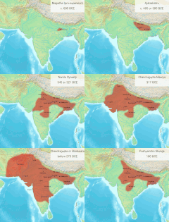
ચિત્ર:Magadha Expansion 1.gif
(૬૮૦ × ૫૯૩ પીક્સલ, ફાઇલનું કદ: ૨.૭૮ MB, MIME પ્રકાર: image/gif, આવર્તન (લુપ),
૧૨ છબીઓ, ૧૫ s)
ફાઇલનો ઇતિહાસ
તારીખ/સમય ઉપર ક્લિક કરવાથી તે સમયે ફાઇલ કેવી હતી તે જોવા મળશે.
| તારીખ/સમય | લઘુચિત્ર | પરિમાણો | સભ્ય | ટિપ્પણી | |
|---|---|---|---|---|---|
| વર્તમાન | ૧૦:૪૪, ૨૫ ડિસેમ્બર ૨૦૨૩ |  | ૬૮૦ × ૫૯૩ (૨.૭૮ MB) | Antiidistorian | Reverted to version as of 07:02, 9 July 2018 (UTC) . This GIF is widely used in the name of Schwartzberg map boundaries. However, it is noteworthy that Schwartzberg accurately incorporated Gedrosia in his map. Please verify: https://dsal.uchicago.edu/reference/schwartzberg/pager.html?object=055. If you intend to make alterations, kindly update the captions on the Gujarati , English and other wiki pages first. Then you, feel free to utilize it as desired. Otherwise, it may mislead individual... |
| ૧૧:૨૧, ૧૬ ડિસેમ્બર ૨૦૨૩ |  | ૬૮૦ × ૫૯૩ (૨.૧૯ MB) | Avantiputra7 | Reverted to version as of 22:58, 29 April 2020 (UTC) | |
| ૨૦:૦૪, ૧૪ ઓક્ટોબર ૨૦૨૩ |  | ૬૮૦ × ૫૯૩ (૨.૨૫ MB) | Rajanyatalk | Reverted to version as of 07:20, 9 July 2018 (UTC) | |
| ૦૪:૨૮, ૩૦ એપ્રિલ ૨૦૨૦ |  | ૬૮૦ × ૫૯૩ (૨.૧૯ MB) | Avantiputra7 | small fixes | |
| ૧૨:૫૦, ૯ જુલાઇ ૨૦૧૮ |  | ૬૮૦ × ૫૯૩ (૨.૨૫ MB) | Avantiputra7 | slowed down for readability | |
| ૧૨:૩૨, ૯ જુલાઇ ૨૦૧૮ |  | ૬૮૦ × ૫૯૩ (૨.૭૮ MB) | Avantiputra7 | User created page with UploadWizard |
ફાઇલનો વપરાશ
આ ફાઇલ માં 3 નીચેનાં પાનાઓ વપરાયેલાં છે:
ફાઇલનો વ્યાપક ઉપયોગ
નીચેની બીજી વિકિઓ આ ફાઈલ વાપરે છે:
- bn.wikipedia.org પર વપરાશ
- ceb.wikipedia.org પર વપરાશ
- cs.wikipedia.org પર વપરાશ
- en.wikipedia.org પર વપરાશ
- fa.wikipedia.org પર વપરાશ
- fr.wikipedia.org પર વપરાશ
- hi.wikipedia.org પર વપરાશ
- hy.wikipedia.org પર વપરાશ
- id.wikipedia.org પર વપરાશ
- it.wikipedia.org પર વપરાશ
- ja.wikipedia.org પર વપરાશ
- ko.wikipedia.org પર વપરાશ
- ms.wikipedia.org પર વપરાશ
- pa.wikipedia.org પર વપરાશ
- pnb.wikipedia.org પર વપરાશ
- ta.wikipedia.org પર વપરાશ
- te.wikipedia.org પર વપરાશ
- ur.wikipedia.org પર વપરાશ
- zh.wikipedia.org પર વપરાશ
