ચિત્ર:Map of Christmas Island 1976.jpg

આ પૂર્વાવલોકનનું કદ: ૬૫૭ × ૬૦૦ પિક્સેલ. અન્ય આવર્તનો: ૨૬૩ × ૨૪૦ પિક્સેલ | ૫૨૬ × ૪૮૦ પિક્સેલ | ૮૩૯ × ૭૬૬ પિક્સેલ.
મૂળભુત ફાઇલ (૮૩૯ × ૭૬૬ પીક્સલ, ફાઇલનું કદ: ૬૯૨ KB, MIME પ્રકાર: image/jpeg)
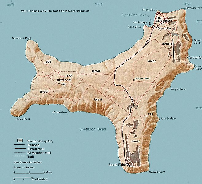
સારાંશ:
| વર્ણન | Map of Christmas. This map was produced by the U.S. Central Intelligence Agency, unless otherwise indicated. Maps dated 1976 were taken from The Indian Ocean Atlas, published by the Central Intelligence Agency. |
| તારીખ | dated 1976 |
| સ્રોત | http://www.lib.utexas.edu/maps/islands_oceans_poles/christmas_island_76.jpg |
| લેખક | Unknown author |
પરવાના
| This image is a work of a Central Intelligence Agency employee, taken or made as part of that person's official duties. As a Work of the United States Government, this image or media is in the public domain in the United States.
|

|
ફાઇલનો ઇતિહાસ
તારીખ/સમય ઉપર ક્લિક કરવાથી તે સમયે ફાઇલ કેવી હતી તે જોવા મળશે.
| તારીખ/સમય | લઘુચિત્ર | પરિમાણો | સભ્ય | ટિપ્પણી | |
|---|---|---|---|---|---|
| વર્તમાન | ૨૦:૫૪, ૩ ફેબ્રુઆરી ૨૦૧૮ | | ૮૩૯ × ૭૬૬ (૬૯૨ KB) | Hohum | Cleanup |
| ૦૨:૦૩, ૧૯ ડિસેમ્બર ૨૦૧૦ |  | ૮૩૯ × ૭૬૬ (૩૬૫ KB) | Ras67 | cropped | |
| ૦૦:૪૫, ૧૨ ફેબ્રુઆરી ૨૦૦૬ |  | ૮૩૯ × ૭૭૪ (૧૨૮ KB) | Walden69 | Map of Christmas. This map were produced by the U.S. Central Intelligence Agency, unless otherwise indicated. Maps dated 1976 were taken from The Indian Ocean Atlas, published by the Central Intelligence Agency. {{PD-USGov-CIA}} |
ફાઇલનો વપરાશ
આ ફાઇલ માં નીચેનું પાનું વપરાયેલું છે:
ફાઇલનો વ્યાપક ઉપયોગ
નીચેની બીજી વિકિઓ આ ફાઈલ વાપરે છે:
- ar.wikipedia.org પર વપરાશ
- arz.wikipedia.org પર વપરાશ
- ast.wikipedia.org પર વપરાશ
- bs.wikipedia.org પર વપરાશ
- ca.wikipedia.org પર વપરાશ
- ceb.wikipedia.org પર વપરાશ
- de.wikipedia.org પર વપરાશ
- el.wikipedia.org પર વપરાશ
- en.wikipedia.org પર વપરાશ
- Christmas Island
- Christmas Island Airport
- Christmas imperial pigeon
- Postage stamps and postal history of Christmas Island
- List of butterflies of Australia
- Murray Hill, Christmas Island
- List of moths of Christmas Island
- Christmas Island Phosphate Co.'s Railway
- Christmas Island flying fox
- Wildlife of Christmas Island
- en.wikiversity.org પર વપરાશ
- en.wikivoyage.org પર વપરાશ
- eo.wikipedia.org પર વપરાશ
- es.wikipedia.org પર વપરાશ
- et.wikipedia.org પર વપરાશ
- eu.wikipedia.org પર વપરાશ
- fa.wikipedia.org પર વપરાશ
- fr.wikipedia.org પર વપરાશ
- gl.wikipedia.org પર વપરાશ
- hi.wikipedia.org પર વપરાશ
- hi.wiktionary.org પર વપરાશ
- hu.wikipedia.org પર વપરાશ
- it.wikipedia.org પર વપરાશ
- ja.wikipedia.org પર વપરાશ
- kk.wikipedia.org પર વપરાશ
- la.wikipedia.org પર વપરાશ
- lld.wikipedia.org પર વપરાશ
- ml.wikipedia.org પર વપરાશ
- ms.wikipedia.org પર વપરાશ
- nn.wikipedia.org પર વપરાશ
આ ફાઇલના વધુ વૈશ્વિક વપરાશ જુઓ.