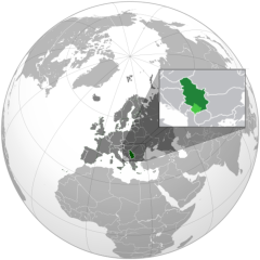
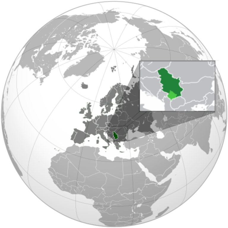
ચિત્ર:Serbia (orthographic projection).svg

Size of this PNG preview of this SVG file: ૬૦૦ × ૬૦૦ પિક્સેલ. અન્ય આવર્તનો: ૨૪૦ × ૨૪૦ પિક્સેલ | ૪૮૦ × ૪૮૦ પિક્સેલ | ૭૬૮ × ૭૬૮ પિક્સેલ | ૧,૦૨૪ × ૧,૦૨૪ પિક્સેલ | ૨,૦૪૮ × ૨,૦૪૮ પિક્સેલ.
મૂળભુત ફાઇલ (SVG ફાઇલ, માત્ર ૨,૦૪૮ × ૨,૦૪૮ પીક્સલ, ફાઇલનું કદ: ૧.૪૫ MB)
સારાંશ:
| વર્ણન |
English: Serbia orthographic projection |
||
| તારીખ | |||
| સ્રોત |
પોતાની રચના This vector image includes elements that have been taken or adapted from this file: This vector image includes elements that have been taken or adapted from this file: This vector image includes elements that have been taken or adapted from this file: |
||
| લેખક | Милан Јелисавчић | ||
| અન્ય આવૃત્તિઓ |
.svg)
|
||
| SVG genesis |
.svg)
.svg)
.svg)
.svg)
.svg)
.svg)
.svg)
.svg)
.svg)
.svg)
.svg)
.svg)
.svg)
.svg)
.svg)
.svg)
.svg)
.svg)
.svg)
.svg)
.svg)
.svg)
.svg)
.svg)
.svg)
.svg)
.svg)
.svg)
.svg)
.svg)
.svg)
.svg)
.svg)
.svg)
.svg)
.svg)
.svg)
.svg)
.svg)
.svg)
.svg)
.svg)
.svg)
.svg)
.svg)
.svg)
.svg)
.svg)
.svg)
.svg)
.svg)
.svg)
.svg)
.svg)
.svg)
.svg)
.svg)
.svg)
.svg)
.svg)
.svg)
.svg)
.svg)
.svg)
.svg)
.svg)
.svg)
.svg)
.svg)
.svg)
.svg)
.svg)
.svg)

.svg)

.svg)

.svg)
.svg)
.svg)
.svg)
.svg)
.svg)
.svg)


.svg)
.svg)
.svg)
.svg)
.svg)
.svg)
.svg)

.svg)
.svg)
.svg)
.svg)
.svg)
.svg)
.svg)
.svg)
.svg)

.svg)
.svg)
.svg)
.svg)
.svg)
.svg)
.svg)
_without_national_boundaries.svg)
.svg)
.svg)
.svg)
.svg)
.svg)
.svg)

.svg)
.svg)
.png)
.svg)
.svg)
.svg)
.svg)

.svg)
.svg)
.svg)
.svg)
.svg)
.svg)
.svg)
.svg)
.svg)
.svg)
.svg)

.svg)
.svg)
.svg)
.svg)
.svg)
.svg)
.svg)
.svg)
.svg)

.svg)
.svg)

.svg)
.svg)
.svg)
.svg)
.svg)
.svg)
.svg)
.svg)
.svg)
.svg)
.svg)
.svg)
.svg)
.svg)
.svg)
.svg)
.svg)
.svg)
.svg)
.svg)
.svg)
.svg)
.svg)
.svg)
.svg)
.svg)
.svg)
_-_Crimea_disputed.svg)
.svg)
.svg)
.svg)
.svg)
.svg)
.svg)
.svg)
.svg)
.svg)
.svg)
.svg)
_political.svg)
.svg)
.svg)
.svg)
.svg)
_-_Crimea_disputed_-_no_borders.svg)
.svg)
.svg)
.svg)
.svg)
.svg)
.svg)
.svg)
.svg)
.svg)
.svg)
.svg)

.svg)
.svg)
.svg)

.png)
.svg)
.svg)
.svg)
.svg)
.svg)
.svg)
.svg)
.svg)
.svg)
.svg)
.svg)
.svg)
.svg)
.svg)
.svg)
.svg)
.svg)
.svg)
.svg)
.svg)
.svg)
.svg)
.svg)
.svg)
.svg)
.svg)
.svg)
.svg)
.svg)
.svg)
.svg)
.svg)
.svg)
.svg)
.png)
.svg)
.svg)
.svg)
_(orthographic_projection).png)

.svg)
.svg)
.svg)
પરવાના
હું, આ કાર્યનો પ્રકાશનાધિકાર ધારક, તેને નીચેના પરવાના હેઠળ અહીં પ્રકાશીત કરૂં છું:
આ ફાઈલ વપરાશની પરવાનગી : Creative Commons Attribution-Share Alike 3.0 Unported license.
- તમે મુક્ત છો:
- વહેંચવા – નકલ કરવા, વિતરણ કરવા અને રચનાઓ મોકલવા
- રીમિક્સ કરવા કે મઠારવા – રચના અપનાવવા
- નીચેની શરત હેઠળ:
- આરોપણ – તમારે આ રચનાનો ઉપયોગ કરવા માટે લેખક કે પ્રકાશન અધિકાર ધારકની યોગ્ય માહિતી, પરવાનગી (લાયસન્સ)ની કડી અને તેમાં ફેરફાર કર્યો હોય તો તેનો ઉલ્લેખ કરવો જ પડશે. તમે આ સત્તા અનુસાર જ આ રચનાનો પ્રયોગ થવો જોઈએ, પણ તેઓ તમને અથવા તમારા ઉપયોગ સાથે સંમત થાય છે તે રીતે નહીં.
- શેર- અલાઈક (બિન ભેદભાવ વહેંચણી) – તમે જો આ રચનાને બદલશો, તેમાં ફેરફાર કરશો અથવા તેના પર આધારિત કોઇ કાર્ય બનાવશો તો તમારે પરિણામી કાર્યને તે જ અથવા અનુરૂપ પરવાનગી હેઠળ જ પ્રકાશિત કરવું પડશે.
ફાઇલનો ઇતિહાસ
તારીખ/સમય ઉપર ક્લિક કરવાથી તે સમયે ફાઇલ કેવી હતી તે જોવા મળશે.
.svg&dir=prev)
.svg&offset=20120121141735)
.svg&offset=&limit=20)
.svg&offset=&limit=50)
.svg&offset=&limit=100)
.svg&offset=&limit=250)
.svg&offset=&limit=500)
| તારીખ/સમય | લઘુચિત્ર | પરિમાણો | સભ્ય | ટિપ્પણી | |
|---|---|---|---|---|---|
| વર્તમાન | ૦૦:૦૪, ૨૮ ડિસેમ્બર ૨૦૨૨ | | ૨,૦૪૮ × ૨,૦૪૮ (૧.૪૫ MB) | Iktsokh | More correct visualization of the dividing line on the territory of the Caucasus Range |
| ૧૨:૧૭, ૨૪ ફેબ્રુઆરી ૨૦૨૨ |  | ૫૪૧ × ૫૪૧ (૨૦૫ KB) | Ahmet Q. | Reverted to version as of 18:50, 15 December 2021 (UTC) Rv POV-pushing | |
| ૦૦:૦૨, ૨૭ ડિસેમ્બર ૨૦૨૧ |  | ૫૪૧ × ૫૪૧ (૩૩૮ KB) | Vacant0 | Reverted to version as of 18:33, 4 June 2021 (UTC) | |
| ૦૦:૨૦, ૧૬ ડિસેમ્બર ૨૦૨૧ |  | ૫૪૧ × ૫૪૧ (૨૦૫ KB) | موسى | Reverted to version as of 23:32, 30 June 2020 (UTC) - саботаж; зеленый цвет в Африке | |
| ૦૦:૦૩, ૫ જૂન ૨૦૨૧ |  | ૫૪૧ × ૫૪૧ (૩૩૮ KB) | Vacant0 | Reverted to version as of 15:49, 29 December 2019 (UTC) | |
| ૦૫:૦૨, ૧ જુલાઇ ૨૦૨૦ |  | ૫૪૧ × ૫૪૧ (૨૦૫ KB) | Yeetstuff | Fixed inaccuracies (EU as whole country, French Guiana colored in, Eritrea and South Sudan not shown, Yemen split) | |
| ૨૧:૧૯, ૨૯ ડિસેમ્બર ૨૦૧૯ |  | ૫૪૧ × ૫૪૧ (૩૩૮ KB) | Goran tek-en | Added border for South Sudan as requested by Maphobbyist | |
| ૦૬:૦૭, ૨૨ જાન્યુઆરી ૨૦૧૨ |  | ૫૪૧ × ૫૪૧ (૬૫૪ KB) | Zenfiric | minor corrections | |
| ૨૦:૧૪, ૨૧ જાન્યુઆરી ૨૦૧૨ |  | ૫૪૧ × ૫૪૧ (૬૫૧ KB) | Zenfiric | minor correction | |
| ૧૯:૪૭, ૨૧ જાન્યુઆરી ૨૦૧૨ |  | ૫૪૧ × ૫૪૧ (૬૫૧ KB) | Zenfiric | Projection with inset |
ફાઇલનો વપરાશ
આ ફાઇલ માં નીચેનું પાનું વપરાયેલું છે:
ફાઇલનો વ્યાપક ઉપયોગ
નીચેની બીજી વિકિઓ આ ફાઈલ વાપરે છે:
- af.wikipedia.org પર વપરાશ
- arc.wikipedia.org પર વપરાશ
- ar.wikipedia.org પર વપરાશ
- العلاقات العراقية الصربية
- العلاقات الأمريكية الصربية
- العلاقات الأنغولية الصربية
- العلاقات الصربية الكورية الجنوبية
- العلاقات الإريترية الصربية
- العلاقات السويسرية الصربية
- العلاقات الألمانية الصربية
- العلاقات الصربية الليختنشتانية
- العلاقات البوليفية الصربية
- العلاقات الصربية الموزمبيقية
- العلاقات الألبانية الصربية
- العلاقات البلجيكية الصربية
- العلاقات الإثيوبية الصربية
- العلاقات البيلاروسية الصربية
- العلاقات الصربية الطاجيكستانية
- العلاقات الروسية الصربية
- العلاقات الرومانية الصربية
- العلاقات الأرجنتينية الصربية
- العلاقات الصربية الغامبية
- العلاقات الصربية القبرصية
- العلاقات السيراليونية الصربية
- العلاقات الصربية النيبالية
- العلاقات الصربية الليبيرية
- العلاقات التشيكية الصربية
- العلاقات الصربية الميانمارية
- العلاقات الصربية الكندية
- العلاقات السعودية الصربية
- العلاقات الزيمبابوية الصربية
- العلاقات الإسرائيلية الصربية
- العلاقات البالاوية الصربية
- العلاقات الصربية المالية
- العلاقات الصربية النيجيرية
- العلاقات اليمنية الصربية
- العلاقات الصربية الفانواتية
- العلاقات الغابونية الصربية
- العلاقات البنمية الصربية
- العلاقات الصربية الكوبية
- العلاقات الجورجية الصربية
- العلاقات التونسية الصربية
- العلاقات الصربية الكورية الشمالية
- العلاقات الهندية الصربية
- العلاقات اليابانية الصربية
- العلاقات الإيطالية الصربية
- العلاقات الصربية الناوروية
- العلاقات الأسترالية الصربية
- العلاقات الزامبية الصربية
- العلاقات الصربية الفيجية
- العلاقات المارشالية الصربية
આ ફાઇલના વધુ વૈશ્વિક વપરાશ જુઓ.
.svg)
.svg)