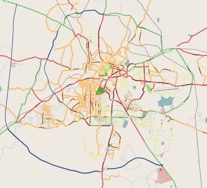
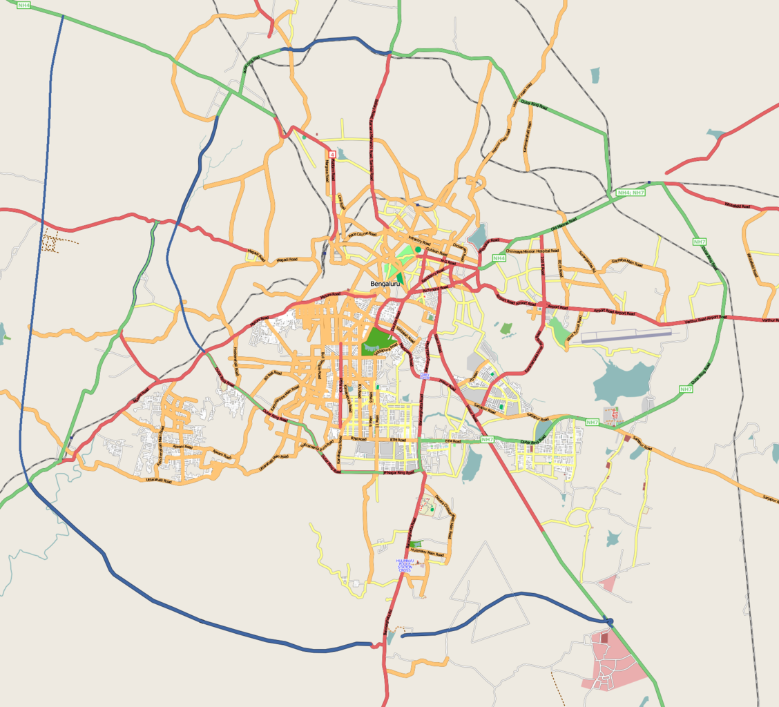
ચિત્ર:Bangalore street Map.png

આ પૂર્વાવલોકનનું કદ: ૬૬૧ × ૬૦૦ પિક્સેલ. અન્ય આવર્તનો: ૨૬૪ × ૨૪૦ પિક્સેલ | ૫૨૯ × ૪૮૦ પિક્સેલ | ૮૪૬ × ૭૬૮ પિક્સેલ | ૧,૧૨૮ × ૧,૦૨૪ પિક્સેલ | ૧,૭૨૨ × ૧,૫૬૩ પિક્સેલ.
મૂળભુત ફાઇલ (૧,૭૨૨ × ૧,૫૬૩ પીક્સલ, ફાઇલનું કદ: ૮૫૫ KB, MIME પ્રકાર: image/png)
| વર્ણન | |
| તારીખ |
૩૧ ડિસેમ્બર ૨૦૦૮ (original upload date) |
| સ્રોત | openstreetmap.org |
| લેખક | Collaboratively created by the OpenStreetMap community using only free map sources and manual GPS surveying to build the map from scratch. Raise lkblr grabbed this image from OpenStreetMap |
| પરવાનગી (આ ફાઈલનો ફરી ઉપયોગ) |
See OpenStreetMap License for details. |
| અન્ય આવૃત્તિઓ | The 'live' version of this map is available at http://www.openstreetmap.org/?lat=12.9536&lon=77.598&zoom=13 Use the 'export' tab to get a fresh export in a variety of formats, including SVG and '.osm', the underlying geolocated data. Use the 'edit' tab there to edit the map! |
સારાંશ:
Latitudes from 77.46 to 77.72
Longitude from 12.83 to 13.06
પરવાના
આ ફાઈલ વપરાશની પરવાનગી : Creative Commons Attribution 2.0 Generic license.
- તમે મુક્ત છો:
- વહેંચવા – નકલ કરવા, વિતરણ કરવા અને રચનાઓ મોકલવા
- રીમિક્સ કરવા કે મઠારવા – રચના અપનાવવા
- નીચેની શરત હેઠળ:
- આરોપણ – તમારે આ રચનાનો ઉપયોગ કરવા માટે લેખક કે પ્રકાશન અધિકાર ધારકની યોગ્ય માહિતી, પરવાનગી (લાયસન્સ)ની કડી અને તેમાં ફેરફાર કર્યો હોય તો તેનો ઉલ્લેખ કરવો જ પડશે. તમે આ સત્તા અનુસાર જ આ રચનાનો પ્રયોગ થવો જોઈએ, પણ તેઓ તમને અથવા તમારા ઉપયોગ સાથે સંમત થાય છે તે રીતે નહીં.
અસલ - મૂળ અપલોડનો લોગ
Transferred from en.wikipedia to Commons by Closedmouth.
The original description page was here. All following user names refer to en.wikipedia.
- 2008-12-31 03:39 Raise lkblr 1722×1563× (789839 bytes)
- 2008-12-30 08:49 Raise lkblr 1656×1019× (632450 bytes) updated
- 2008-12-30 08:34 Raise lkblr 1517×1520× (790374 bytes) from http://openstreetmap.org/
ફાઇલનો ઇતિહાસ
તારીખ/સમય ઉપર ક્લિક કરવાથી તે સમયે ફાઇલ કેવી હતી તે જોવા મળશે.
| તારીખ/સમય | લઘુચિત્ર | પરિમાણો | સભ્ય | ટિપ્પણી | |
|---|---|---|---|---|---|
| વર્તમાન | ૧૨:૦૨, ૨૦ જુલાઇ ૨૦૧૨ | | ૧,૭૨૨ × ૧,૫૬૩ (૮૫૫ KB) | Wantsallanger | enhanced contrast |
| ૧૨:૨૯, ૪ માર્ચ ૨૦૧૧ |  | ૧,૭૨૨ × ૧,૫૬૩ (૮૬૧ KB) | Raise lkblr | updated completed ring road | |
| ૨૦:૧૭, ૨૪ માર્ચ ૨૦૦૯ |  | ૧,૭૨૨ × ૧,૫૬૩ (૭૭૧ KB) | Closedmouth | {{Information |Description={{en|Map of en:Bangalore, India<br/> en:Category:OpenStreetMap maps}} |Source=Transferred from [http://en.wikipedia.org en.wikipedia]; transfer was stated to be made by User:Closedmouth.<br/> (Original text : ''[ht |
ફાઇલનો વપરાશ
આ ફાઇલ માં નીચેનું પાનું વપરાયેલું છે:
ફાઇલનો વ્યાપક ઉપયોગ
નીચેની બીજી વિકિઓ આ ફાઈલ વાપરે છે:
- af.wikipedia.org પર વપરાશ
- ar.wikipedia.org પર વપરાશ
- ba.wikipedia.org પર વપરાશ
- bn.wikipedia.org પર વપરાશ
- বোম্মনাহাল্লি
- ইলেকট্রনিক সিটি
- মডিউল:অবস্থান মানচিত্র/উপাত্ত/ভারত বেঙ্গালুরু
- মডিউল:অবস্থান মানচিত্র/উপাত্ত/ভারত বেঙ্গালুরু/নথি
- বিধান সৌধ
- ডাঃ বি.আর. আম্বেদকর স্টেশন, বিধান সৌধ মেট্রো স্টেশন
- স্বামী বিবেকানন্দ রোড মেট্রো স্টেশন
- বাইয়াপ্পনহাল্লি মেট্রো স্টেশন
- ইন্দিরানগর মেট্রো স্টেশন
- হালাসুরু মেট্রো স্টেশন
- মহাত্মা গান্ধী রোড মেট্রো স্টেশন (বেঙ্গালুরু)
- কাবন পার্ক মেট্রো স্টেশন
- কেঙ্গেরি মেট্রো স্টেশন
- ca.wikipedia.org પર વપરાશ
- ceb.wikipedia.org પર વપરાશ
- en.wikipedia.org પર વપરાશ
- Visvesvaraya Industrial and Technological Museum
- Vidhana Soudha
- Whitefield, Bangalore
- B.M.S. College of Engineering
- R.V. College of Engineering
- Jayanagar, Bangalore
- Lal Bagh
- Domlur
- Madiwala
- Basaveshwaranagara
- Koramangala
- Hebbal, Bangalore
- Indiranagar
- HSR Layout
- Begur, Bangalore
- Basavanagudi
- Sri Chamarajendra Udyanavana
- Ulsoor
- Hulimavu
- Shivajinagar, Bangalore
- Yelachenahalli
- Bommanahalli
- Gottigere
- Kengeri
- Konanakunte
- Krishnarajapuram
- Mahadevapura, Bangalore
- Uttarahalli
- Malleshwaram, Bengaluru
- Hoodi
- Arekere
- Gavi Gangadhareshwara Temple
આ ફાઇલના વધુ વૈશ્વિક વપરાશ જુઓ.