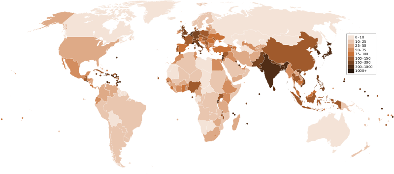
ચિત્ર:Countries by population density.svg

Size of this PNG preview of this SVG file: ૮૦૦ × ૩૫૩ પિક્સેલ. અન્ય આવર્તનો: ૩૨૦ × ૧૪૧ પિક્સેલ | ૬૪૦ × ૨૮૨ પિક્સેલ | ૧,૦૨૪ × ૪૫૨ પિક્સેલ | ૧,૨૮૦ × ૫૬૫ પિક્સેલ | ૨,૫૬૦ × ૧,૧૨૯ પિક્સેલ | ૬,૦૦૦ × ૨,૬૪૭ પિક્સેલ.
મૂળભુત ફાઇલ (SVG ફાઇલ, માત્ર ૬,૦૦૦ × ૨,૬૪૭ પીક્સલ, ફાઇલનું કદ: ૧.૬૨ MB)
ફાઇલનો ઇતિહાસ
તારીખ/સમય ઉપર ક્લિક કરવાથી તે સમયે ફાઇલ કેવી હતી તે જોવા મળશે.
| તારીખ/સમય | લઘુચિત્ર | પરિમાણો | સભ્ય | ટિપ્પણી | |
|---|---|---|---|---|---|
| વર્તમાન | ૦૫:૦૩, ૨૨ ડિસેમ્બર ૨૦૧૧ |  | ૬,૦૦૦ × ૨,૬૪૭ (૧.૬૨ MB) | Quibik | added transparency |
| ૧૯:૧૩, ૨૦ ફેબ્રુઆરી ૨૦૧૧ |  | ૬,૦૦૦ × ૨,૬૪૭ (૧.૬૨ MB) | Erik del Toro Streb | typographically corrected | |
| ૦૭:૫૨, ૭ જાન્યુઆરી ૨૦૦૮ |  | ૬,૦૦૦ × ૨,૬૪૭ (૧.૬૨ MB) | Briefplan~commonswiki | {{Information |Description=A map of the world, with colours to highlight the population density of each country or territory. Numbers on the legend are in people per km<sup>2</sup>, and all countries smaller than 20,000 km<sup>2</sup> are represented by a |
ફાઇલનો વપરાશ
આ ફાઇલ માં નીચેનું પાનું વપરાયેલું છે:
ફાઇલનો વ્યાપક ઉપયોગ
નીચેની બીજી વિકિઓ આ ફાઈલ વાપરે છે:
- af.wikipedia.org પર વપરાશ
- ar.wikipedia.org પર વપરાશ
- arz.wikipedia.org પર વપરાશ
- ast.wikipedia.org પર વપરાશ
- av.wikipedia.org પર વપરાશ
- awa.wikipedia.org પર વપરાશ
- azb.wikipedia.org પર વપરાશ
- az.wikipedia.org પર વપરાશ
- ba.wikipedia.org પર વપરાશ
- be.wikipedia.org પર વપરાશ
- bg.wikipedia.org પર વપરાશ
- bs.wikipedia.org પર વપરાશ
- ca.wikipedia.org પર વપરાશ
- ckb.wikipedia.org પર વપરાશ
- cs.wikipedia.org પર વપરાશ
- cy.wikipedia.org પર વપરાશ
- de.wikipedia.org પર વપરાશ
- de.wikiversity.org પર વપરાશ
- diq.wikipedia.org પર વપરાશ
- dsb.wikipedia.org પર વપરાશ
- en.wikipedia.org પર વપરાશ
- eo.wikipedia.org પર વપરાશ
- es.wikipedia.org પર વપરાશ
- eu.wikipedia.org પર વપરાશ
- fi.wikipedia.org પર વપરાશ
- fr.wikipedia.org પર વપરાશ
આ ફાઇલના વધુ વૈશ્વિક વપરાશ જુઓ.