ચિત્ર:DesertStormMap v2.svg

Size of this PNG preview of this SVG file: ૮૦૦ × ૫૬૩ પિક્સેલ. અન્ય આવર્તનો: ૩૨૦ × ૨૨૫ પિક્સેલ | ૬૪૦ × ૪૫૧ પિક્સેલ | ૧,૦૨૪ × ૭૨૧ પિક્સેલ | ૧,૨૮૦ × ૯૦૧ પિક્સેલ | ૨,૫૬૦ × ૧,૮૦૨ પિક્સેલ | ૧,૫૦૦ × ૧,૦૫૬ પિક્સેલ.
મૂળભુત ફાઇલ (SVG ફાઇલ, માત્ર ૧,૫૦૦ × ૧,૦૫૬ પીક્સલ, ફાઇલનું કદ: ૩.૧૩ MB)
|

સારાંશ:
This W3C-unspecified vector image was created with Inkscape .
| શીર્ષક |
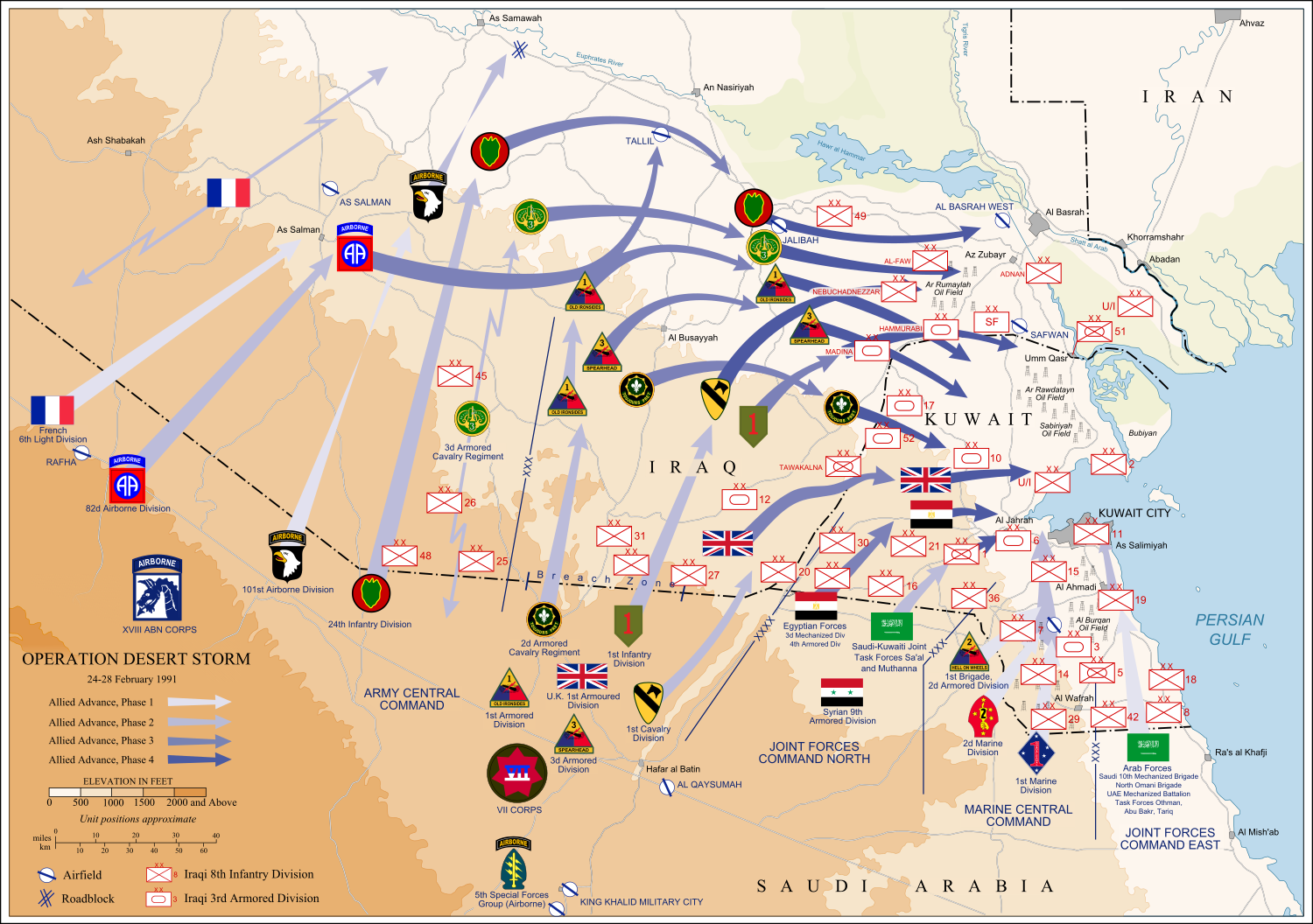
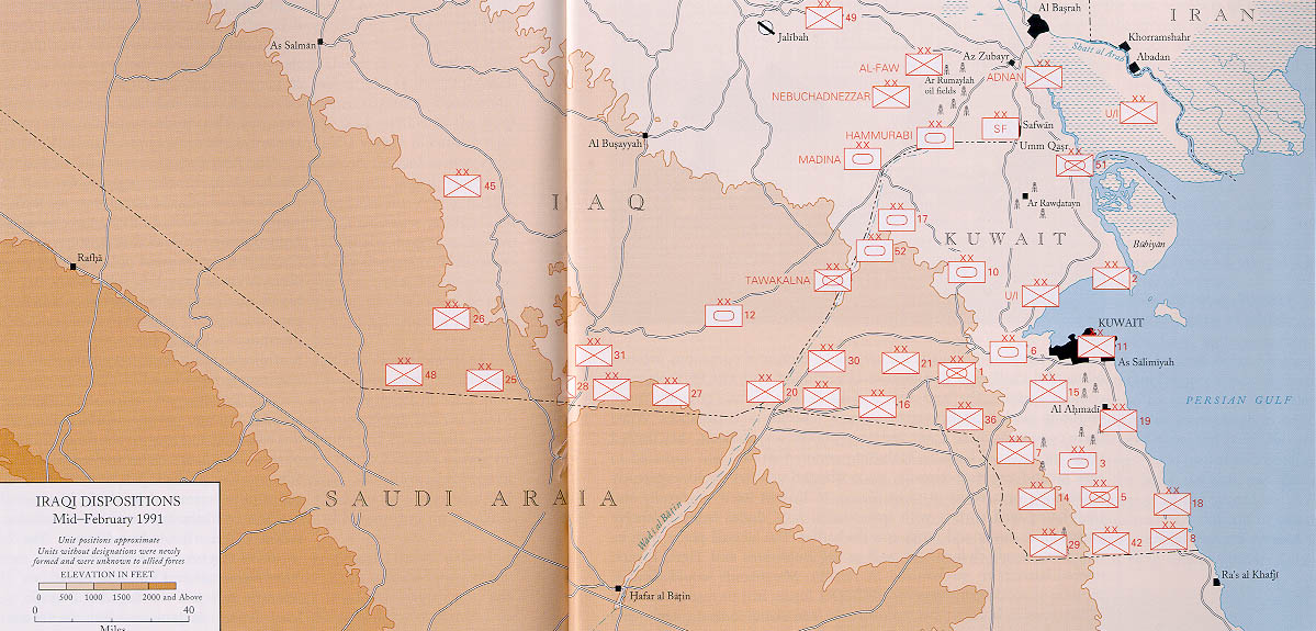
Operation Desert Storm |
||||
| Description |
العربية: عملية عاصفة الصحراء، ضمن حرب الخليج الثانية، 24-28 شباط/ فبراير 1991.
English: Map of ground operations of Operation Desert Storm starting invasion February 24-28th 1991. Shows allied and Iraqi forces. Special arrows indicate the American 101st Airborne division moved by air and where the French 6st light division and American 3rd Armored Cavalry Regiment provided security.
Français : Carte montrant les opérations terrestres menées lors de l'opération Tempête du désert entre le 24 et le 28 février 1991 : les positions tenues par les armées irakienne et alliées, et les mouvements de cette dernière. Des flèches particulières indiquent les manœuvres héliportées pratiquées par la 101e division aéroportée, ainsi que les zones sécurisées par la 6e brigade légère blindée française et par le 3e régiment blindé de cavalerie américain. |
||||
| તારીખ | (UTC) | ||||
| સ્રોત | self-vectored from Image:Operation Desert Storm.jpg from this site and this site. | ||||
| રચયિતા |
US Army |
||||
| Geotemporal data | |||||
| Date depicted | |||||
| Map location | Iraq/Kuwait border | ||||
| OpenStreetMap zoom level | 9 | ||||
| Bounding box |
|
||||
| Georeferencing | |||||
| Bibliographic data | |||||
| ભાષા | eng | ||||
| Archival data | |||||
| માધ્યમ | Inkscape SVG | ||||
| અન્ય આવૃત્તિઓ |
 |
||||

પરવાના
This file is a work of a U.S. Army soldier or employee, taken or made as part of that person's official duties. As a work of the U.S. federal government, it is in the public domain in the United States.
|
 |
હું, આ કાર્યનો પ્રકાશનાધિકાર ધારક, તેને નીચેના પરવાનાઓ હેઠળ અહીં પ્રકાશીત કરૂં છું:

|
આ રચનાની નકલ કરવા, વિતરણ અને સુધારો કરવા માટે GNU Free Documentation License, આવૃત્તિ 1.2 કે અન્ય આગળની આવૃત્તિ Free Software Foundation હેઠળ પરવાનગી છે; જેમાં કોઈ Invariant Sections, no Front-Cover Texts, and no Back-Cover Texts નથી. આ પરવાનાની પ્રત GNU Free Documentation License વિભાગમાં છે. |
This file is licensed under the Creative Commons Attribution-Share Alike 4.0 International, 3.0 Unported, 2.5 Generic, 2.0 Generic and 1.0 Generic license.
- તમે મુક્ત છો:
- વહેંચવા – નકલ કરવા, વિતરણ કરવા અને રચનાઓ મોકલવા
- રીમિક્સ કરવા કે મઠારવા – રચના અપનાવવા
- નીચેની શરત હેઠળ:
- આરોપણ – તમારે આ રચનાનો ઉપયોગ કરવા માટે લેખક કે પ્રકાશન અધિકાર ધારકની યોગ્ય માહિતી, પરવાનગી (લાયસન્સ)ની કડી અને તેમાં ફેરફાર કર્યો હોય તો તેનો ઉલ્લેખ કરવો જ પડશે. તમે આ સત્તા અનુસાર જ આ રચનાનો પ્રયોગ થવો જોઈએ, પણ તેઓ તમને અથવા તમારા ઉપયોગ સાથે સંમત થાય છે તે રીતે નહીં.
- શેર- અલાઈક (બિન ભેદભાવ વહેંચણી) – તમે જો આ રચનાને બદલશો, તેમાં ફેરફાર કરશો અથવા તેના પર આધારિત કોઇ કાર્ય બનાવશો તો તમારે પરિણામી કાર્યને તે જ અથવા અનુરૂપ પરવાનગી હેઠળ જ પ્રકાશિત કરવું પડશે.
તમે તમારી પસંદગીનો પરવાનો પસંદ કરી શકો છો.
ફાઇલનો ઇતિહાસ
તારીખ/સમય ઉપર ક્લિક કરવાથી તે સમયે ફાઇલ કેવી હતી તે જોવા મળશે.
| તારીખ/સમય | લઘુચિત્ર | પરિમાણો | સભ્ય | ટિપ્પણી | |
|---|---|---|---|---|---|
| વર્તમાન | ૧૮:૪૪, ૯ જૂન ૨૦૧૨ | | ૧,૫૦૦ × ૧,૦૫૬ (૩.૧૩ MB) | Coolland | uploaded with x-external-editor |
| ૧૦:૦૧, ૬ ફેબ્રુઆરી ૨૦૦૮ |  | ૧,૫૦૦ × ૧,૦૫૬ (૩.૧૩ MB) | Jeff Dahl | flags/label edits | |
| ૦૨:૩૦, ૫ ફેબ્રુઆરી ૨૦૦૮ |  | ૧,૫૦૦ × ૧,૦૫૬ (૨.૮૯ MB) | Jeff Dahl | == Summary == {{Inkscape}} {{Information |Description=Map of ground operations of Operation Desert Storm from February 24-28th 1991. Shows allied and Iraqi forces. |Source=self-made, vectored from Image:Operation Desert Storm.jpg from [http://www.his |
ફાઇલનો વપરાશ
આ ફાઇલ માં નીચેનું પાનું વપરાયેલું છે:
ફાઇલનો વ્યાપક ઉપયોગ
નીચેની બીજી વિકિઓ આ ફાઈલ વાપરે છે:
- an.wikipedia.org પર વપરાશ
- ar.wikipedia.org પર વપરાશ
- bg.wikipedia.org પર વપરાશ
- br.wikipedia.org પર વપરાશ
- ca.wikipedia.org પર વપરાશ
- cs.wikipedia.org પર વપરાશ
- de.wikipedia.org પર વપરાશ
- el.wikipedia.org પર વપરાશ
- en.wikipedia.org પર વપરાશ
- French Foreign Legion
- Kuwait Armed Forces
- Armed Forces of Saudi Arabia
- 101st Airborne Division
- 82nd Airborne Division
- Gulf War
- 1st Cavalry Division (United States)
- 3rd Armored Division (United States)
- VII Corps (United States)
- 24th Infantry Division (United States)
- Norman Schwarzkopf Jr.
- 1st (United Kingdom) Division
- Air assault
- Battle of Khafji
- Royal Green Jackets (Rifles) Museum
- Iraqi invasion of Kuwait
- List of conflicts in Asia
- Opération Daguet
- Portal:Maps/Selected picture
- 1st Foreign Cavalry Regiment
- Wikipedia:WikiProject Iraq
- Wikipedia:Featured pictures thumbs/10
- Wikipedia:Featured picture candidates/February-2008
- Wikipedia:Featured picture candidates/Operation Desert Storm
- Wikipedia:Wikipedia Signpost/2008-02-18/Features and admins
- User talk:Jeff Dahl/Archive 3
- 82nd Sustainment Brigade
- Wikipedia:Featured pictures/Diagrams, drawings, and maps/Maps
- Wikipedia:WikiProject United States Government
- Wikipedia:Picture of the day/July 2008
- Template:POTD/2008-07-27
- User talk:Jeff Dahl/Archive 4
- Wikipedia:Wikipedia Signpost/2008-02-18/SPV
- Portal:Maps/Selected picture/38
- Wikipedia:WikiProject Military history/Showcase
- Wikipedia:WikiProject Military history/Showcase/FP
- 1st Brigade, 24th Infantry Division (United States)
આ ફાઇલના વધુ વૈશ્વિક વપરાશ જુઓ.