ચિત્ર:ElectoralCollege2004.svg

Size of this PNG preview of this SVG file: ૮૦૦ × ૪૬૫ પિક્સેલ. અન્ય આવર્તનો: ૩૨૦ × ૧૮૬ પિક્સેલ | ૬૪૦ × ૩૭૨ પિક્સેલ | ૧,૦૨૪ × ૫૯૫ પિક્સેલ | ૧,૨૮૦ × ૭૪૪ પિક્સેલ | ૨,૫૬૦ × ૧,૪૮૮ પિક્સેલ | ૧,૦૨૦ × ૫૯૩ પિક્સેલ.
મૂળભુત ફાઇલ (SVG ફાઇલ, માત્ર ૧,૦૨૦ × ૫૯૩ પીક્સલ, ફાઇલનું કદ: ૨૯ KB)
સારાંશ:
| U.S. presidential election maps (SVG) |
| See also: National Atlas maps (png) |
|
1789 · 1792 · 1796 · 1800 · 1804 · 1808 · 1812 · 1816 · 1820 · 1824 · 1828 · 1832 · 1836 · 1840 · 1844 · 1848 · 1852 · 1856 · 1860 · 1864 · 1868 · 1872 · 1876 · 1880 · 1884 · 1888 · 1892 · 1896 · 1900 · 1904 · 1908 · 1912 · 1916 · 1920 · 1924 · 1928 · 1932 · 1936 · 1940 · 1944 · 1948 · 1952 · 1956 · 1960 · 1964 · 1968 · 1972 · 1976 · 1980 · 1984 · 1988 · 1992 · 1996 · 2000 · 2004 · 2008 · 2012 · 2016 · 2020 · 2024 |
| વર્ણન |
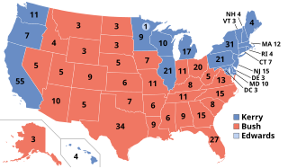
English: Electoral college votes in the 2004 United States Presidential election |
| તારીખ | |
| સ્રોત | પોતાની રચના |
| લેખક | Nkocharh (talk) |
પરવાના
| આ રચના ના લેખક Nkocharh at અંગ્રેજી વિકિપીડિયા દ્વારા આ રચનાને public domain હેઠળ પ્રકાશિત કરાઈ છે. આ સવલત વિશ્વવ્યપી છે અમુક દેશોમાં કાયદેસર રીતે તે શક્ય નથી, જો તેમ હોય તો : Nkocharh દ્વારા કોઈને પણ કોઈપણ વપરાશ, કોઇ પણ શરત વગર, માટે આ રચના વાપરવાની છૂટ આપાઈ છે સિવાયકે તે શરતો કાયદેસર જરૂરી હોય. |
અસલ - મૂળ અપલોડનો લોગ
Transferred from en.wikipedia to Commons by Furfur using CommonsHelper.
The original description page was here. All following user names refer to en.wikipedia.
- 2008-03-06 21:49 Nkocharh 1020×593×??? (122642 bytes) Desaturated the colors to match all the other maps to be found here: http://en.wikipedia.org/wiki/United_States_presidential_election_maps
ફાઇલનો ઇતિહાસ
તારીખ/સમય ઉપર ક્લિક કરવાથી તે સમયે ફાઇલ કેવી હતી તે જોવા મળશે.
| તારીખ/સમય | લઘુચિત્ર | પરિમાણો | સભ્ય | ટિપ્પણી | |
|---|---|---|---|---|---|
| વર્તમાન | ૧૩:૫૫, ૨૨ ડિસેમ્બર ૨૦૧૮ | | ૧,૦૨૦ × ૫૯૩ (૨૯ KB) | Newfraferz87 | New template |
| ૧૬:૨૯, ૬ ફેબ્રુઆરી ૨૦૧૭ |  | ૧,૦૨૦ × ૫૯૩ (૩૫ KB) | Newfraferz87 | Clearer state borders | |
| ૦૯:૨૨, ૨૧ ડિસેમ્બર ૨૦૧૬ |  | ૧,૦૨૦ × ૫૯૩ (૩૫ KB) | Newfraferz87 | There's no need to make that distinction; there was only one "Bush" running for president that year. | |
| ૧૮:૩૮, ૧૧ ડિસેમ્બર ૨૦૧૬ |  | ૧,૦૨૦ × ૫૯૩ (૧૧૪ KB) | Χ | label G.W. Bush | |
| ૦૩:૩૦, ૮ નવેમ્બર ૨૦૧૬ |  | ૧,૦૨૦ × ૫૯૩ (૧૨૦ KB) | Wow | Edwards | |
| ૦૨:૩૬, ૩ સપ્ટેમ્બર ૨૦૦૮ |  | ૧,૦૨૦ × ૫૯૩ (૧૨૦ KB) | File Upload Bot (Magnus Manske) | {{BotMoveToCommons|en.wikipedia}} {{Information |Description={{en|Electoral college votes in the 2004 United States Presidential election<br/> en:Category:Maps of the United States en:Category:United States presidential election, 2004 [[:en:Ca |
ફાઇલનો વપરાશ
આ ફાઇલ માં 2 નીચેનાં પાનાઓ વપરાયેલાં છે:
ફાઇલનો વ્યાપક ઉપયોગ
નીચેની બીજી વિકિઓ આ ફાઈલ વાપરે છે:
- arz.wikipedia.org પર વપરાશ
- as.wikipedia.org પર વપરાશ
- azb.wikipedia.org પર વપરાશ
- bg.wikipedia.org પર વપરાશ
- bh.wikipedia.org પર વપરાશ
- bs.wikipedia.org પર વપરાશ
- cdo.wikipedia.org પર વપરાશ
- cy.wikipedia.org પર વપરાશ
- dag.wikipedia.org પર વપરાશ
- da.wikipedia.org પર વપરાશ
- de.wikipedia.org પર વપરાશ
- el.wikipedia.org પર વપરાશ
- eml.wikipedia.org પર વપરાશ
- en.wikipedia.org પર વપરાશ
- Presidency of George W. Bush
- 2004 United States presidential election
- 2004 United States presidential election in California
- 2004 United States presidential election in Illinois
- 2004 United States presidential election in Texas
- 2004 United States presidential election in Florida
- 2004 United States presidential election in Pennsylvania
- 2004 United States presidential election in Ohio
- 2004 United States presidential election in Georgia
- 2004 United States presidential election in Iowa
- 2004 United States presidential election in New Jersey
- 2004 United States presidential election in Wisconsin
- 2004 United States presidential election in Alabama
- 2004 United States presidential election in Arizona
- 2004 United States presidential election in Arkansas
- 2004 United States presidential election in Colorado
- 2004 United States presidential election in Delaware
- 2004 United States presidential election in Connecticut
- 2004 United States presidential election in Hawaii
- 2004 United States presidential election in New York
- 2004 United States presidential election in New Hampshire
- 2004 United States presidential election in Vermont
આ ફાઇલના વધુ વૈશ્વિક વપરાશ જુઓ.