ચિત્ર:Mauritius (+claim islands).svg

Size of this PNG preview of this SVG file: ૫૦૦ × ૪૬૩ પિક્સેલ. અન્ય આવર્તનો: ૨૫૯ × ૨૪૦ પિક્સેલ | ૫૧૮ × ૪૮૦ પિક્સેલ | ૮૨૯ × ૭૬૮ પિક્સેલ | ૧,૧૦૬ × ૧,૦૨૪ પિક્સેલ | ૨,૨૧૨ × ૨,૦૪૮ પિક્સેલ.
મૂળભુત ફાઇલ (SVG ફાઇલ, માત્ર ૫૦૦ × ૪૬૩ પીક્સલ, ફાઇલનું કદ: ૧.૪૧ MB)
.svg)
સારાંશ:
| વર્ણન |
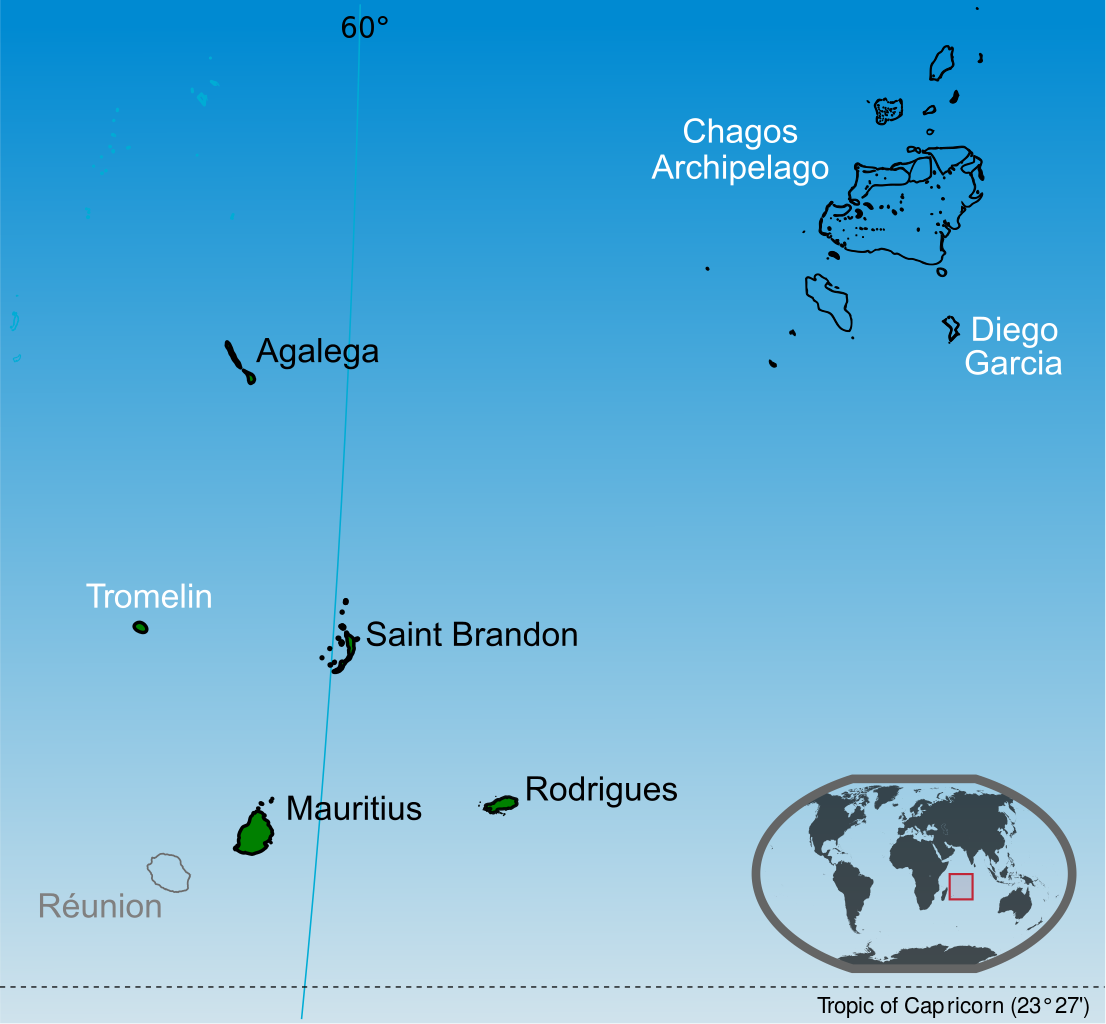
English: Islands of the Republic of Mauritius labelled in black. Mauritius claim Tromelin island claim from France and the Chagos Archipelago from the United Kingdom. |
| તારીખ | |
| સ્રોત |
પોતાની રચના This vector image includes elements that have been taken or adapted from this file: This vector image includes elements that have been taken or adapted from this file: This vector image includes elements that have been taken or adapted from this file: This vector image includes elements that have been taken or adapted from this file: This vector image includes elements that have been taken or adapted from this file: This vector image includes elements that have been taken or adapted from this file: |
| લેખક | Yashveer Poonit |
| અન્ય આવૃત્તિઓ | Macedonian version |
_mk.svg)
પરવાના
હું, આ કાર્યનો પ્રકાશનાધિકાર ધારક, તેને નીચેના પરવાના હેઠળ અહીં પ્રકાશીત કરૂં છું:
આ ફાઈલ વપરાશની પરવાનગી : Creative Commons Attribution-Share Alike 3.0 Unported license.
- તમે મુક્ત છો:
- વહેંચવા – નકલ કરવા, વિતરણ કરવા અને રચનાઓ મોકલવા
- રીમિક્સ કરવા કે મઠારવા – રચના અપનાવવા
- નીચેની શરત હેઠળ:
- આરોપણ – તમારે આ રચનાનો ઉપયોગ કરવા માટે લેખક કે પ્રકાશન અધિકાર ધારકની યોગ્ય માહિતી, પરવાનગી (લાયસન્સ)ની કડી અને તેમાં ફેરફાર કર્યો હોય તો તેનો ઉલ્લેખ કરવો જ પડશે. તમે આ સત્તા અનુસાર જ આ રચનાનો પ્રયોગ થવો જોઈએ, પણ તેઓ તમને અથવા તમારા ઉપયોગ સાથે સંમત થાય છે તે રીતે નહીં.
- શેર- અલાઈક (બિન ભેદભાવ વહેંચણી) – તમે જો આ રચનાને બદલશો, તેમાં ફેરફાર કરશો અથવા તેના પર આધારિત કોઇ કાર્ય બનાવશો તો તમારે પરિણામી કાર્યને તે જ અથવા અનુરૂપ પરવાનગી હેઠળ જ પ્રકાશિત કરવું પડશે.
ફાઇલનો ઇતિહાસ
તારીખ/સમય ઉપર ક્લિક કરવાથી તે સમયે ફાઇલ કેવી હતી તે જોવા મળશે.
| તારીખ/સમય | લઘુચિત્ર | પરિમાણો | સભ્ય | ટિપ્પણી | |
|---|---|---|---|---|---|
| વર્તમાન | ૦૬:૫૪, ૧૪ જુલાઇ ૨૦૧૪ | | ૫૦૦ × ૪૬૩ (૧.૪૧ MB) | Yash400 | use accurate map of Chagos |
| ૧૮:૨૯, ૨૦ જાન્યુઆરી ૨૦૧૪ |  | ૫૦૦ × ૪૬૩ (૧.૩૭ MB) | Palosirkka | larger nominal size | |
| ૦૦:૨૦, ૨૦ જાન્યુઆરી ૨૦૧૪ |  | ૨૫૫ × ૨૩૬ (૧.૩૭ MB) | Yash400 | remove black lines | |
| ૨૩:૫૫, ૧૯ જાન્યુઆરી ૨૦૧૪ |  | ૨૫૭ × ૨૩૮ (૧.૩૭ MB) | Yash400 | change color | |
| ૨૩:૩૮, ૨૦ નવેમ્બર ૨૦૧૩ |  | ૫૭૨ × ૫૩૦ (૧.૪૧ MB) | Yash400 | User created page with UploadWizard |
ફાઇલનો વપરાશ
આ ફાઇલ માં નીચેનું પાનું વપરાયેલું છે:
ફાઇલનો વ્યાપક ઉપયોગ
નીચેની બીજી વિકિઓ આ ફાઈલ વાપરે છે:
- af.wikipedia.org પર વપરાશ
- ar.wikipedia.org પર વપરાશ
- avk.wikipedia.org પર વપરાશ
- bh.wikipedia.org પર વપરાશ
- bn.wikipedia.org પર વપરાશ
- br.wikipedia.org પર વપરાશ
- ca.wikipedia.org પર વપરાશ
- ceb.wikipedia.org પર વપરાશ
- ckb.wikipedia.org પર વપરાશ
- de.wikipedia.org પર વપરાશ
- diq.wikipedia.org પર વપરાશ
- dty.wikipedia.org પર વપરાશ
- en.wikipedia.org પર વપરાશ
- es.wikipedia.org પર વપરાશ
- eu.wikipedia.org પર વપરાશ
- fa.wikipedia.org પર વપરાશ
- fi.wikipedia.org પર વપરાશ
- frp.wikipedia.org પર વપરાશ
- fr.wikipedia.org પર વપરાશ
- gl.wikipedia.org પર વપરાશ
- id.wikipedia.org પર વપરાશ
- ilo.wikipedia.org પર વપરાશ
- incubator.wikimedia.org પર વપરાશ
- io.wikipedia.org પર વપરાશ
- ja.wikipedia.org પર વપરાશ
- ka.wikipedia.org પર વપરાશ
- lv.wikipedia.org પર વપરાશ
આ ફાઇલના વધુ વૈશ્વિક વપરાશ જુઓ.
.svg)
.svg)