ચિત્ર:Subtes-2015.svg

Size of this PNG preview of this SVG file: ૬૯૪ × ૫૯૯ પિક્સેલ. અન્ય આવર્તનો: ૨૭૮ × ૨૪૦ પિક્સેલ | ૫૫૬ × ૪૮૦ પિક્સેલ | ૮૮૯ × ૭૬૮ પિક્સેલ | ૧,૧૮૬ × ૧,૦૨૪ પિક્સેલ | ૨,૩૭૧ × ૨,૦૪૮ પિક્સેલ | ૧,૬૫૦ × ૧,૪૨૫ પિક્સેલ.
મૂળભુત ફાઇલ (SVG ફાઇલ, માત્ર ૧,૬૫૦ × ૧,૪૨૫ પીક્સલ, ફાઇલનું કદ: ૧૪૩ KB)
| વર્ણન |
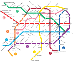
Español: Mapa de la red de subterráneos de la Ciudad de Buenos Aires hacia 2015, con todas las líneas proyectadas según ley 670 de la C.A.B.A.. |
||||||||
| સ્રોત | Galio, own work. | ||||||||
| લેખક | Galio | ||||||||
| પરવાનગી (આ ફાઈલનો ફરી ઉપયોગ) |
હું, આ કાર્યનો પ્રકાશનાધિકાર ધારક, તેને નીચેના પરવાનાઓ હેઠળ અહીં પ્રકાશીત કરૂં છું:
આ ફાઈલ વપરાશની પરવાનગી : Creative Commons Attribution 2.5 Generic license.
તમે તમારી પસંદગીનો પરવાનો પસંદ કરી શકો છો. |

ફાઇલનો ઇતિહાસ
તારીખ/સમય ઉપર ક્લિક કરવાથી તે સમયે ફાઇલ કેવી હતી તે જોવા મળશે.
| તારીખ/સમય | લઘુચિત્ર | પરિમાણો | સભ્ય | ટિપ્પણી | |
|---|---|---|---|---|---|
| વર્તમાન | ૧૨:૪૬, ૧૧ જાન્યુઆરી ૨૦૧૬ | | ૧,૬૫૦ × ૧,૪૨૫ (૧૪૩ KB) | SegataSanshiro1 | Smaller station icons, made interchanges clearer. |
| ૦૧:૦૫, ૨ સપ્ટેમ્બર ૨૦૧૫ |  | ૧,૬૫૦ × ૧,૪૨૫ (૧૬૯ KB) | SegataSanshiro1 | Colours changed to match official colours, added Premetro | |
| ૧૧:૦૭, ૯ જૂન ૨૦૧૩ |  | ૧,૬૫૦ × ૧,૪૨૫ (૧૫૯ KB) | Galio | la denominación oficial de las estaciones es S. J. de Flores y San Pedrito, "Flores" a secas y Nazca son obsoletos | |
| ૦૯:૦૩, ૧૧ જૂન ૨૦૧૦ |  | ૧,૬૫૦ × ૧,૪૨૫ (૧૩૨ KB) | Dexxter | Estaciones proyectadas de Línea A: Flores y Nazca. | |
| ૦૫:૨૨, ૯ ફેબ્રુઆરી ૨૦૦૯ |  | ૧,૬૫૦ × ૧,૪૨૫ (૧૫૯ KB) | Galio | Modificación ubicación Carabobo | |
| ૦૫:૫૦, ૨૬ ઓગસ્ટ ૨૦૦૮ |  | ૧,૬૫૦ × ૧,૪૨૫ (૧૫૯ KB) | Ojota | Category:Buenos Aires Metro | |
| ૦૮:૨૭, ૧૪ જુલાઇ ૨૦૦૮ |  | ૧,૬૫૦ × ૧,૪૨૫ (૧૫૮ KB) | Galio | {{Information |Description= |Source= |Date= |Author= |Permission= |other_versions= }} | |
| ૦૬:૪૮, ૧૪ જુલાઇ ૨૦૦૮ |  | ૧,૬૫૦ × ૧,૪૨૫ (૧૫૯ KB) | Galio | {{Information |Description= |Source= |Date= |Author= |Permission= |other_versions= }} {{ImageUpload|basic}} | |
| ૦૩:૪૫, ૧૪ જુલાઇ ૨૦૦૮ |  | ૧,૬૫૦ × ૧,૪૨૫ (૧૫૯ KB) | Galio | {{Information |Description= |Source= |Date= |Author= |Permission= |other_versions= }} | |
| ૧૨:૦૫, ૧૩ જુલાઇ ૨૦૦૮ |  | ૧,૬૫૦ × ૧,૪૨૫ (૧૬૧ KB) | Galio | == Sumario == Mapa de la red de subterráneos de la Ciudad de Buenos Aires hacia 2015, con todas las líneas proyectadas según ley 670 de la C.A.B.A. == Licensing == {{self2|GFDL|cc-by-2.5}} Category:Public transport maps of Buenos Aires {{ImageUpl |
ફાઇલનો વપરાશ
આ ફાઇલને કોઇ પાનાં વાપરતા નથી.
ફાઇલનો વ્યાપક ઉપયોગ
નીચેની બીજી વિકિઓ આ ફાઈલ વાપરે છે:
- ca.wikipedia.org પર વપરાશ
- en.wikipedia.org પર વપરાશ
- es.wikipedia.org પર વપરાશ
- fr.wikipedia.org પર વપરાશ
- hy.wikipedia.org પર વપરાશ
- id.wikipedia.org પર વપરાશ
- it.wikipedia.org પર વપરાશ
- ja.wikipedia.org પર વપરાશ
- nl.wikipedia.org પર વપરાશ
- ru.wikipedia.org પર વપરાશ
- th.wikipedia.org પર વપરાશ
- uk.wikipedia.org પર વપરાશ