ચિત્ર:Auckland20061016222837.jpg

આ પૂર્વાવલોકનનું કદ: ૬૭૪ × ૬૦૦ પિક્સેલ. અન્ય આવર્તનો: ૨૭૦ × ૨૪૦ પિક્સેલ | ૫૩૯ × ૪૮૦ પિક્સેલ | ૮૬૩ × ૭૬૮ પિક્સેલ | ૧,૧૫૧ × ૧,૦૨૪ પિક્સેલ | ૨,૩૦૧ × ૨,૦૪૮ પિક્સેલ | ૫,૫૯૯ × ૪,૯૮૩ પિક્સેલ.
મૂળભુત ફાઇલ (૫,૫૯૯ × ૪,૯૮૩ પીક્સલ, ફાઇલનું કદ: ૧૦.૧૫ MB, MIME પ્રકાર: image/jpeg)
સારાંશ:
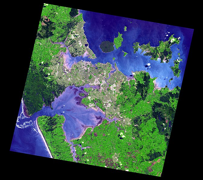
Satellite image of Auckland, New Zealand, and the islands of the inner Hauraki Gulf.
Data Acquired: 2006-10-16
Corner points:
- Image width = 5599 height = 4983 bands = 3
Geo Projection
- Top Left -36.611691 174.364053
- Lat Increment 0.0001350000 Long Increment 0.0001689228
Full Image:-
- UL = -36.611691 174.364053 UR = -36.611691 175.309683
- LL = -37.284261 174.364053 LR = -37.284261 175.309683
Actual Image:-
- Image_UL = -36.623571 174.567099 Image_UR = -36.720366 175.267959
- Image_LL = -37.175316 174.409325 Image_LR = -37.272651 175.115253
- Image_UL_Loc = 1202 88 Image_UR_Loc = 5351 805
- Image_LL_Loc = 268 4175 Image_LR_Loc = 4447 4896
Source: http://ava.jpl.nasa.gov/public/2006/10/16/20061016222837-1200x1200.jpg[dead link], listed on this page archive copy at the Wayback Machine in the ASTER Volcano Archive.
Larger version stored in this image's history was downloaded from http://ava.jpl.nasa.gov/public/2006/10/16/20061016222837.jpg[dead link].
.jpg)
.jpg)
.jpg)
.jpg)
.jpg)
.jpg)
પરવાના
| This file is in the public domain in the United States because it was solely created by NASA. NASA copyright policy states that "NASA material is not protected by copyright unless noted". (See Template:PD-USGov, NASA copyright policy page or JPL Image Use Policy.) | ||
 |
Warnings:
|
ફાઇલનો ઇતિહાસ
તારીખ/સમય ઉપર ક્લિક કરવાથી તે સમયે ફાઇલ કેવી હતી તે જોવા મળશે.
| તારીખ/સમય | લઘુચિત્ર | પરિમાણો | સભ્ય | ટિપ્પણી | |
|---|---|---|---|---|---|
| વર્તમાન | ૦૬:૧૮, ૨૪ સપ્ટેમ્બર ૨૦૧૩ | | ૫,૫૯૯ × ૪,૯૮૩ (૧૦.૧૫ MB) | Avenue | Higher resolution |
| ૧૪:૫૫, ૮ સપ્ટેમ્બર ૨૦૦૭ |  | ૧,૨૦૦ × ૧,૦૬૮ (૨૨૪ KB) | Avenue | Satellite image of Auckland, New Zealand, and the islands of the inner Hauraki Gulf. Data Acquired: 2006-10-16 Corner points: * Image width = 5599 height = 4983 bands = 3 Geo Projection * Top Left -36.611691 174.364053 * Lat Increment 0.0001350000 L | |
| ૧૪:૪૮, ૮ સપ્ટેમ્બર ૨૦૦૭ |  | ૫,૫૯૯ × ૪,૯૮૩ (૫.૪૪ MB) | Avenue | Satellite image of Auckland, New Zealand, and the islands of the inner Hauraki Gulf. Data Acquired: 2006-10-16 Corner points: Image width = 5599 height = 4983 bands = 3 Geo Projection Top Left -36.611691 174.364053 Lat Increment 0.0001350000 Long |
ફાઇલનો વપરાશ
આ ફાઇલ માં નીચેનું પાનું વપરાયેલું છે:
ફાઇલનો વ્યાપક ઉપયોગ
નીચેની બીજી વિકિઓ આ ફાઈલ વાપરે છે:
- kn.wikipedia.org પર વપરાશ
- nn.wikipedia.org પર વપરાશ