ચિત્ર:Houston Ship Channel Barbours Cut.jpg

આ પૂર્વાવલોકનનું કદ: ૮૦૦ × ૫૩૪ પિક્સેલ. અન્ય આવર્તનો: ૩૨૦ × ૨૧૪ પિક્સેલ | ૬૪૦ × ૪૨૭ પિક્સેલ | ૧,૦૨૪ × ૬૮૩ પિક્સેલ | ૧,૫૦૦ × ૧,૦૦૧ પિક્સેલ.
મૂળભુત ફાઇલ (૧,૫૦૦ × ૧,૦૦૧ પીક્સલ, ફાઇલનું કદ: ૬૯૩ KB, MIME પ્રકાર: image/jpeg)
| વર્ણન |
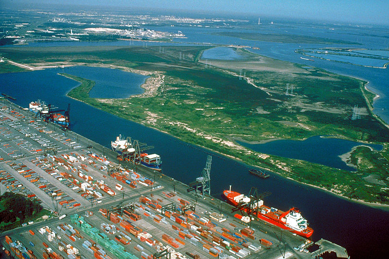
English: Aerial view of the Barbour's Cut area on the Houston Ship Channel in Houston, Texas, USA. This area is a large container terminal. This photograph appears to have been taken before the Fred Hartman Bridge was built, or when the bridge was under construction. In a present-day photograph, the bridge should be clearly visible at top right.
Coordinates: 29°40′54.98″N 94°59′54.37″W / 29.6819389°N 94.9984361°W |
|||
| Location | Houston, Texas, USA | |||
| તારીખ | Probably pre-1995 | |||
| સ્રોત |
U.S. Army Corps of Engineers Digital Visual Library Image page Image description page Digital Visual Library home page |
|||
| લેખક | U.S. Army Corps of Engineers, photographer not specified or unknown | |||
| પરવાનગી (આ ફાઈલનો ફરી ઉપયોગ) |
|
ફાઇલનો ઇતિહાસ
તારીખ/સમય ઉપર ક્લિક કરવાથી તે સમયે ફાઇલ કેવી હતી તે જોવા મળશે.
| તારીખ/સમય | લઘુચિત્ર | પરિમાણો | સભ્ય | ટિપ્પણી | |
|---|---|---|---|---|---|
| વર્તમાન | ૦૬:૫૨, ૧૦ મે ૨૦૦૭ | | ૧,૫૦૦ × ૧,૦૦૧ (૬૯૩ KB) | DanMS | {{Information | Description = {{en|Aerial view of the Barbour's Cut area on the Houston Ship Channel in Houston, Texas, USA. This area is a large container terminal. This photograph appears to have been taken before the Fred Hartman Bridge was built, o |
ફાઇલનો વપરાશ
આ ફાઇલ માં નીચેનું પાનું વપરાયેલું છે:
ફાઇલનો વ્યાપક ઉપયોગ
નીચેની બીજી વિકિઓ આ ફાઈલ વાપરે છે:
- ar.wikipedia.org પર વપરાશ
- bn.wikipedia.org પર વપરાશ
- de.wikipedia.org પર વપરાશ
- en.wikipedia.org પર વપરાશ
- es.wikipedia.org પર વપરાશ
- eu.wikipedia.org પર વપરાશ
- fi.wikipedia.org પર વપરાશ
- fr.wikipedia.org પર વપરાશ
- hu.wikipedia.org પર વપરાશ
- it.wikipedia.org પર વપરાશ
- ja.wikipedia.org પર વપરાશ
- lt.wikipedia.org પર વપરાશ
- ml.wikipedia.org પર વપરાશ
- nl.wikipedia.org પર વપરાશ
- no.wikipedia.org પર વપરાશ
- pl.wikipedia.org પર વપરાશ
- pnb.wikipedia.org પર વપરાશ
- pt.wikipedia.org પર વપરાશ
- ru.wikipedia.org પર વપરાશ
- te.wikipedia.org પર વપરાશ
- tr.wikipedia.org પર વપરાશ
- uk.wikipedia.org પર વપરાશ
- ur.wikipedia.org પર વપરાશ
- uz.wikipedia.org પર વપરાશ
- vi.wikipedia.org પર વપરાશ
- www.wikidata.org પર વપરાશ
આ ફાઇલના વધુ વૈશ્વિક વપરાશ જુઓ.