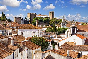
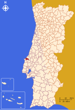
Óbidos
municipality and town of Portugal
ઉદાહરણ
municipality of Portugal
town of Portugal
શરૂઆતની તારીખ: 1195
સત્તાવાર નામ
Óbidos
સ્થાનિક વર્ણન
Óbidos
ઉચ્ચાર ધ્વનિ:
દેશ
પ્રશાસન વિભાગમાં આવેલ છે
લેરીયા જિલ્લો
Oeste Subregion
Estremadura
સ્થળના અક્ષાંસ રેખાંશ
નું સભ્ય
જાહેર રજા
patronal festival
day in year for periodic occurrence: જાન્યુઆરી ૧૧
વસ્તી / જનસંખ્યા
તેના વિભાગો
A dos Negros
Amoreira
Olho Marinho
Vau
Gaeiras
Usseira
Santa Maria, São Pedro e Sobral da Lagoa
સમુદ્ર સપાટીથી ઉંચાઇ
૪૯±૧ મીટર
સરહદ દ્વારા જોડાયેલ
Bombarral
Peniche
Lourinhã
Caldas da Rainha
ક્ષેત્રફળ
૧૪૧.૫૫±૦.૦૧૦૦૦૦૦૦૦૦૦૦૦૧ square kilometre[૧૪]
પોસ્ટલ કોડ
2510
અધિકૃત વેબસાઇટ
patron saint
સ્થાનિક ડાયલિંગ કોડ
262
કોમન્સ શ્રેણી
Óbidos
વિષયની મુખ્ય શ્રેણી
Category:Óbidos, Portugal
category for people who died here
Q26941705
સંદર્ભ
- ↑ Freebase Data Dumps, ૨૮ ઓક્ટોબર 2013
- ↑ https://service.unece.org/trade/locode/pt.htm
- ↑ GeoNames
- ↑ MusicBrainz, ૧૯ મે 2020
- ↑ ઓપેન સ્ટ્રીટ માપ
- ↑ http://mapas.ine.pt/download/files/2011/tabela/categorias.ods
- ↑ Virtual International Authority File, ૩ ઓગસ્ટ 2015
- ↑ iNaturalist, ૨૫ એપ્રિલ 2021, https://www.inaturalist.org/places/inaturalist-places.csv.zip
- ↑ ક્વોરા
- ↑ ઓપેન સ્ટ્રીટ માપ, ૮ જાન્યુઆરી 2023
- ↑ ૯ જૂન 2021, https://en.unesco.org/creative-cities/obidos
- ↑ https://www.ine.pt/xportal/xmain?xlang=en&xpid=INE&xpgid=ine_indicadores&indOcorrCod=0005889&contexto=pi&selTab=tab0
- ↑ http://mail.camara.rj.gov.br/APL/Legislativos/scpro2124.nsf/a6cd246684502db90325863200569384/57f27d29a9147c4a032589aa006cd46b?OpenDocument
- ↑ https://www.ine.pt/xportal/xmain?xpid=INE&xpgid=ine_indicadores&indOcorrCod=0008350&selTab=tab0, National Institute of Statistics, ૧૯ સપ્ટેમ્બર 2018


